This walk was organised and led by me as an irregular CBC Tuesday walk:
(Tuesday 18 December — Burkes Creek and Pipeline Roads — M/E,X. Drive to Top Flats via the recently reopened Bendora Dam Road. Walk a loop, all on fire trail/road, along Burkes Creek Road, Pipeline Road and Bendora Dam Road. See the spectacular face in the cliff and a cameo view up Burkes Creek to The Pimple. Four crossings of the Cotter River as it flows through rugged country. Great views up to the wild western side of the Tidbinbilla Range. Around 14km and 300m total climb. Map: Tidbinbilla 1:25000. Limit of 8. Leader: John Evans – jevans@pcug.org.au, (h) 6288 7235; contact me by 6pm the previous Sunday to discuss options. Transport: ~$12. Further details at http://jevans.pcug.org.au.).
3 of us drove and parked at the junction of Burkes Creek Road and Bendora Dam Road.
Bring your choice of water crossing gear. Choose from nothing (wet feet?), to wade in bare feet (hurts mine), to sandals/thongs and a towel to dry off with. Each walker should carry a minimum of 2 litres of water. On the way back, I'd also like to pop down to Bendora Hut to get a pic - a 10km round drive south along Mt Franklin Road from Bulls Head picnic area and a 2.7km round trip walk.
Route Card
|
Route Card - Burkes Creek and Pipeline Roads |
||||
| Leg | Waypoints | Dist (km) | Going |
Est Time (hh:mm) |
| 1 | 1-2 | 1.2 | From start at Top Flats, walk back along the Bendora Dam Road for 1.3km to the junction with Burkes Creek Road. Pass beneath the white rocky outcrop | 0:15 (act) |
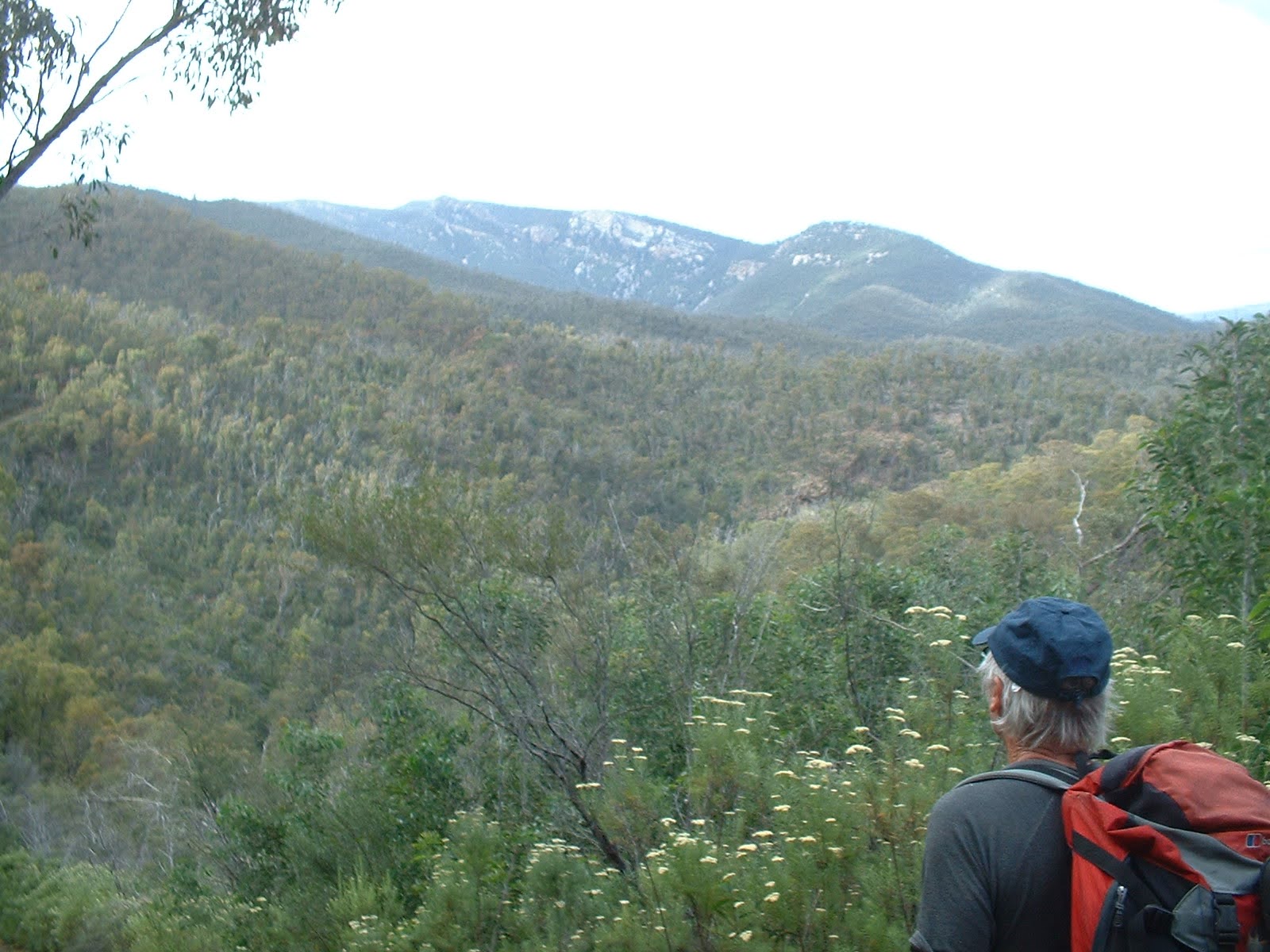
| 2 | 2-3 | 6.9 | Burkes Creek Road parallels the Cotter River for 6.8km. After just 200m the fabulous face in the cliff appears on the other side of the Cotter (see pic 3 at 27 Oct 07). At 500m we cross the Cotter River for the first time. Another 500m further along the exposed Bendora pipeline bridges a gully. 900m on we ford the Cotter River again and, 400m on, yet again. Around this point there is a wonderful view up Burkes Creek with The Pimple towering above the tree tops. Unknown territory for me from this point on, but there should be excellent views up to the W side of the Tidbinbilla Range. The road changes direction from generally NE to generally NW and we intersect with Pipeline Road | 2:30 (est) |
| 3 | 3-4 | 2.7 | 250m on from the intersection we ford the Cotter River for the last time. A 250m climb up Pipeline Road, round the back of SH907. Back to Bendora Dam Road. | 1:00 (est) |
| 4 | 4-1 | 3.1 | A trudge back down Bendora Dam Road to the car at Top Flats | 1:00 (est) |
Walk ![]()
A change of plans on the way in, all agreeing to walk the loop clockwise and to park and start from the junction of Bendora Dam Road and Burkes Creek Road. There are a few of my companions who walk at a fine pace and David and Meredith are two. I was soon panting up the road and failing the talk test. A right turn into Pipeline Road and a lovely walk down through mostly unburnt open forest. A dry ford over a gurgling Cotter River, then up to join Burkes Creek Road and so to touch on the point where we descended from the Hardy Range on 11 Aug 07.
Then a leg SW along Burkes Creek Road (I was tempted but not brave enough to walk across the exposed pipeline) to a second dry ford over the Cotter. This is where we exited from the spur to Camels Hump on 27 Oct 07. Enjoyed the view up to The Pimple and found 10c on the ground. That was about the end of my good fortune for the day. Enjoyed morning tea.
We continued back along Burkes Creek Road, choosing the straight-through-in-boots-and-get-wet method of crossing the next wet ford of the Cotter and enjoying great views up to the west side of the Tidbinbilla Range (see pic 3). Another wet ford, past the face in the cliff and back to the car. This loop 10.9km in 2hr 45mins (incl morning tea).
We'd already decided it was too early to go home, so next drove down to Top Flats. Another, deeper, ford of the Cotter onto the right bank (I think the standard is that left and right banks are determined when facing downstream), this time a little more than shin deep for the shorter member of the party. Headed S up the river towards Bendora Dam, passing the take off point for the first excursion I had made up the W side of the Tidbinbilla Range on 3 Apr 07. The leader had his map in his pack and mind in neutral, so we ended up at the ford at Cow Flats and had to retrace our steps a little to join the track around the big Cotter River loop below the dam. By this time the cicadas were singing loudly and several king parrots had been seen, as well as, all along the roads and trails, Cassinia in flower. We passed the start and exit points for the wander up Cow Flat cliffs on 13 Oct 07. So to the base of Bendora Dam (see pic 3), then up to the top and overlooking the water for lunch. Three guys out on the dam in a tinny, no doubt ActewAGL or ranger people doing measurements but probably wishing they could fish.
Away and up to the picnic area, then down the Bendora Dam Road on the left side of the Cotter, following part of the route taken on my first visit to this area on 21 Oct 06. Past the bottom of the very steep Flat Rock Spur fire trail and the Bendora Break. Back to the car. This loop 9.6km in 2hr 40mins (incl lunch).
Next we drove to the Mt Franklin Road, Moonlight Hollow Road, Chalet Road intersection and wandered down to Bendora Hut to get a pic of it. Alas, I was later to find that the compact flash card in my camera had died. On returning to the car, that oft-imagined, dreaded fear was realised when my car keys were not in the unzipped pocket inside the lid of my pack. So, for the second time with these companions I emptied my pack (the first time was some months ago to find my camera - which was hanging round my neck), to find the keys in a side pocket. This loop 2.4km in 40mins.
Sure - all on hard surface, but walked a bit more of the Cotter River and enjoyed a day with friends. Thanks for your company David and Meredith.
Distance: 22.9km Climb: 600m. Time: 7.50am - 2.35pm (6.75hrs), including 45mins of breaks.
Grading: L/E,X; M(9)
KMZ file for Google Earth/Maps: Burkes Creek and Pipeline Roads, Bendora Dam and Bendora Hut
Photographs courtesy of D&M H