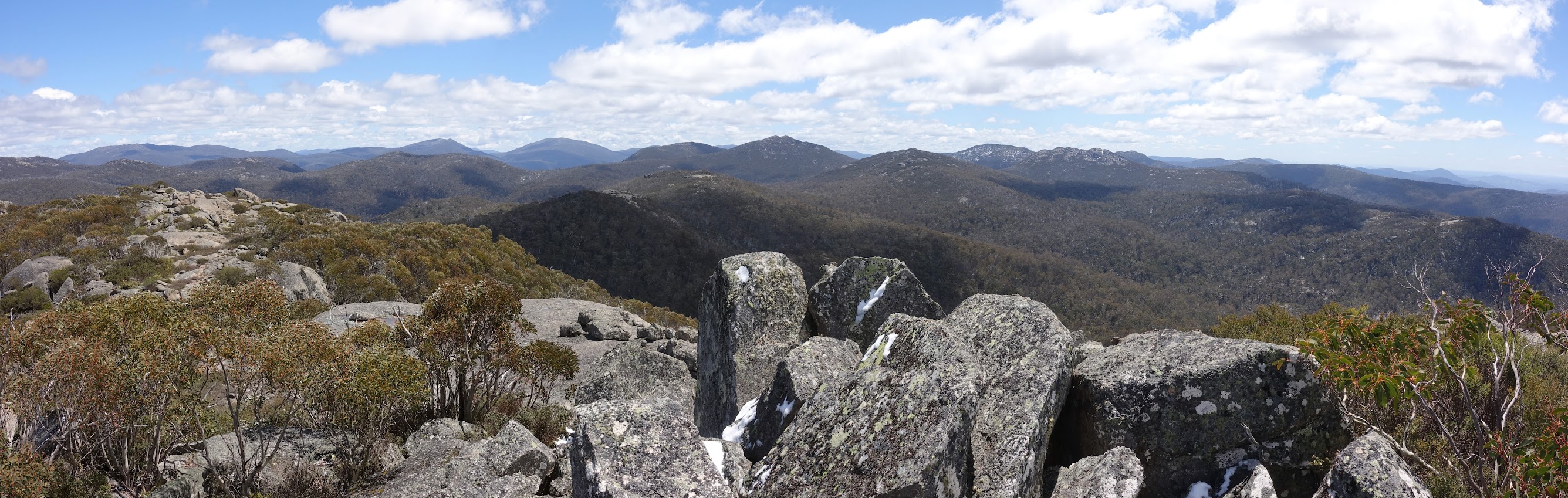
Mts Kelly, Namadgi and Burbidge from Mt Mouat
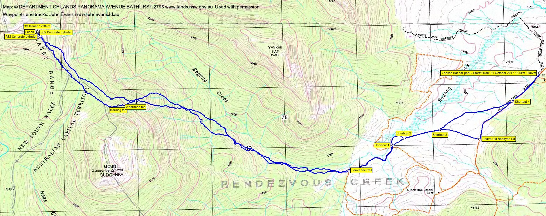
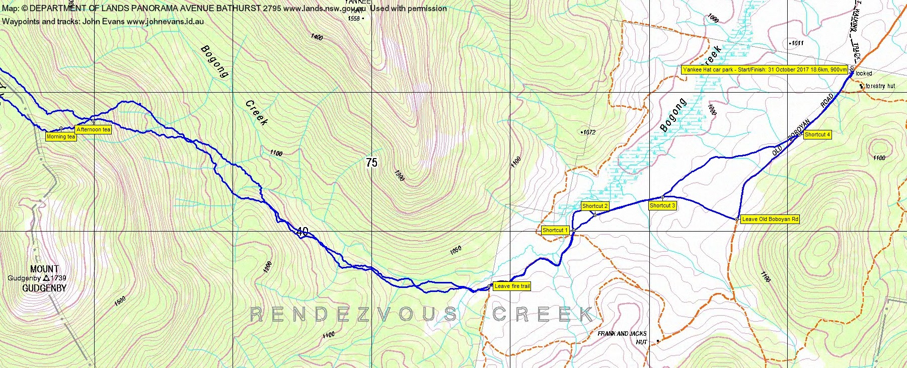
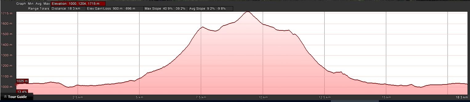
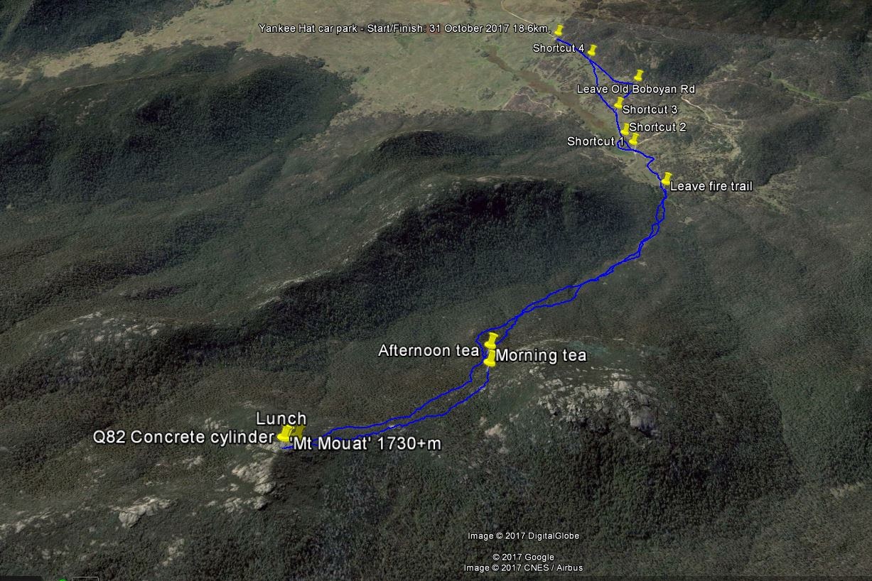
Tuesday 31 October: ‘Mt Mouat’ (aka ‘The Fortress’), Namadgi National Park – L/R. From the Yankee Hat carpark, we’ll follow Bogong Creek for a few kilometres then head northwest, ascending 700 metres to the Scabby Range and the ACT border. ‘Mt Mouat’ (or ‘The Fortress’) is the local name for a prominent knoll 2.5 kilometres northwest of Mount Gudgenby and is on the ACT-NSW border. The return route will be close to the morning route. Most of the day is off-track in steep terrain, with difficult scrubby going in places. 7.5 kilometres of the walk is on fire-trails. Bookings by the Friday night before. Minimum distance: 18 km with 890 metres of ascent. Maps: Rendezvous Creek, Yaouk. Leader: John Evans 0417 436 877 john@johnevans.id.au . Transport: ∼$12 per person. Limit: 8.
Further Information
My previous trips to Mt Mouat were 5 Apr 08 and 30-31 May 15.
Summary
Distance: 18.6km | Climb: 900m | Time: 7.50am – 5.00pm (9hrs 10mins), including 60 mins of breaks | Grading: L/R; H(14+)
Photographs
Photographs are available, where you can start a large sized slideshow.
Videos
Waypoint and Track Files
Download the .gpx file. (Right click, Save Link As…, Save – if you want to use it.)
To use in Google Earth, do File, Open… and select Gps or All files as the File Type.
Track Notes
When you wake up in the morning feeling off your oats, old codgers used to take a BEX, have a cuppa and a lie down. No opportunity to do that at 5.45am this morning, so I took 2 Gatenbys instead. That did the trick! Huge thanks to Philip and Jan for getting me to Mt Mouat and thanks from my dear wife for getting me home.
Philip and Jan are extremely fit walkers and Philip is a consummate route finder. He led ¾ of the off-track part and got pretty wet from the snow in the scrub and falling from the trees.
This was an apt trip, as I understand that the Mouat Tree will soon be ‘opened’/’launched’ at the Namadgi Visitors Centre.
A dusting of snow on the Tidbinbilla Range as we left Canberra. And a lovely surprise view of the surrounding hills similarly dusted when we arrived at the Yankee Hat car park.
Away at 7.50am and 3.7km in 40mins to the fire trail turnoff, now marked by a small cairn near the roll of old fencing.
The next leg took us parallel to Bogong Creek, up to the 1200m contour and crossing 4 side gullies. It was unexpectedly (Relatively – that’s with a capital R) easy walking, with lots of animal runs to follow. But the further we went with little height gain, the steeper it was eventually going to be. 2.6km in 1hr.
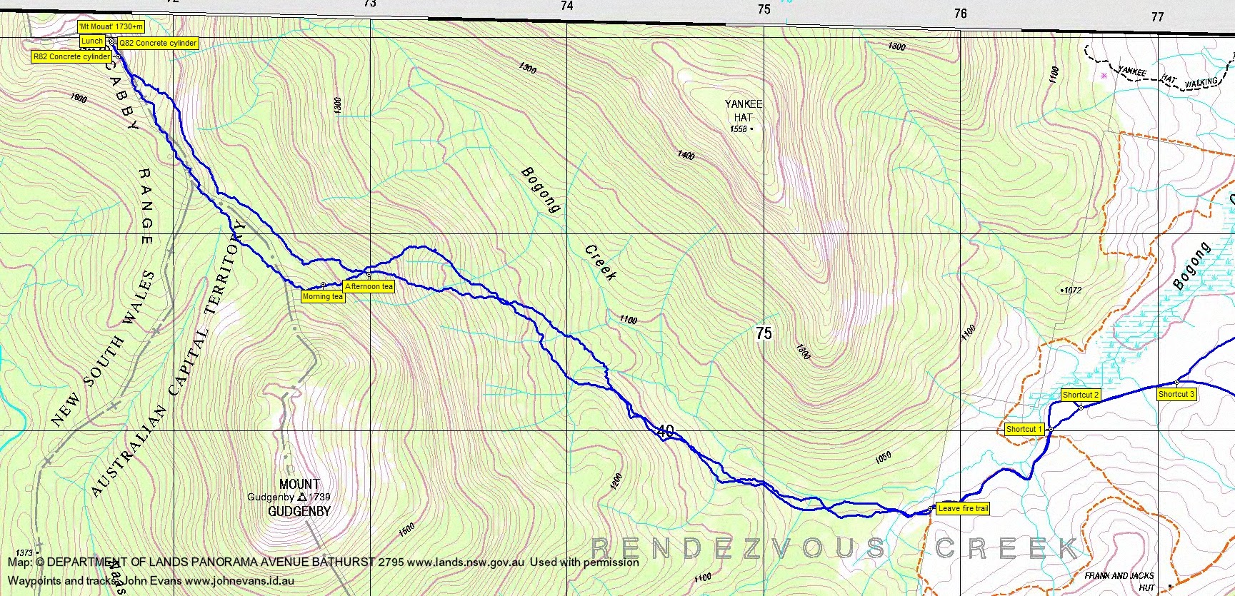
The climb from 1200m to morning tea at 1540m began the really hard stuff. To add to the difficulty, we ran into snow at around 1500m. This leg 1.3km in 1hr. We found a granite slab for morning tea; the sun fitfully appeared to dry Philip’s sodden shirt.
After morning tea we put our raincoats on. The climb to the watershed crest was a little easier, but the flattish saddle between the northern nose of Gudgenby and the southern climb to Mt Mouat was more densely vegetated and the sun had not reached the snow. So we were all pretty wet.Morning tea to the 1530m contour in the saddle was 770m in 30mins.
Another 200vm climb followed to reach Mt Mouat, the going easing a little but still around 1km/hr. 1.2km in 1hr 5mins.
We popped up first at border marker R82 with great views back to Mt Gudgenby. A few tens of metres further on, we reached the top, Mt Mouat! Huge views all round. Have a look at the video and the photos. Lunch and a call home to my dear wife.
I had said to myself many times today, and particularly during the final ascent, that I’ll never do another trip like this. But all that leaves the mind (only to return on the homeward leg) when you reach the top. The ‘flapping old chook’ becomes a ‘soaring eagle’ and the views are exhilarating!
The return trip was a hard slog for me. 9.1km in 4hrs. A few things worth noting. Philip took a parallel route to our inward leg from just off the top to afternoon tea, around 100m to the NE of the crest. It was certainly easier going. I asked him why and he said that it would be either the same, worse or better than our known inward leg and it was just good luck. I think it was expert route finding through an area generally more exposed to the sun. I think I had another go out front next, making an inelegant loop too far down. I was pretty whacked going home. Two lovely little shortcuts once we were out, the second circumventing the grind up the fire trail hill to join the Old Boboyan Road. Now I’ve seen a buck kangaroo gently stroking the face of a female before, Today I saw the male gently patting the end of a female’s tail. I think if I tried patting my dear wife’s tail, there would be a similar reaction – the female roo just ignored him and hopped away. Then again, the buck kept trying ….
Huge trip. Grand views. Thanks so much Philip and Jan. Never again – no next time for me.
Track Maps
Party
3 walkers – Jan G, Philip G, me.