This excursion was organised and led by Keith S as a Namadgi National Park Ranger exercise.
Further Information
I was fortunate enough to meet Keith on 16 Dec 08 when I called in to NVC to pick up a camping permit for 9-10 Jan 09. A few emails later and permission was given for me to join in on a sites of significance hunting trip.
Walk
Keith, Lou and I left NVC around 9am in air conditioned comfort and drove via Naas Road, Caloola Farm and the N 2.5km of the Naas Valley Fire Trail to the gate into NNP. Wonderful, as a back seat passenger, to have the gate unlocked and swung open, without having to get a boot dirty.
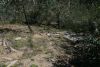
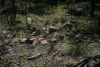
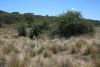
Site 1 - W-G YA3, (unnamed Hut) Tom Rolleys Hut site (from MH material): From here, a 3.5km drive S to the first site. The GPS took us to the S bank of the creek coming in from the W. We crossed and Keith soon found an old bed. But female intuition won out and Lou searched a little further N to find the site. This turned out to be the one marked on the 1st edn Michelago 1:25000 map (not on the 2nd edn), which I'd visited on 3 Jul 07. Description is: "Corrugated asbestos fibro sheeting on sawn timber frame. Poor condition; notable for lack of hearth." (See pic 1).
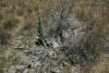
Site 2 - W-G GR7, Reedy Creek Hut Site: 7.6km further S the known GR took us to a drainage line near Reedy Creek, but the site sketch showed a W-E bend in the creek, so we headed N until Keith found the site. Description is: "Atop a knoll around which Reedy Creek makes its only major eastward curve. Three pieces of corrugated metal, a number of roughly shaped poles (none standing) and wire bound around three trees." (See pic 2). That made it staff 2, visitor nil. Also, within a few metres of where we stopped, there was a star picket with yellow tag "SigSite #235". This marks the proximity of indigenous site #235 in the Rangers' database.
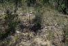
Site 3 - Mrs Matheson's grave (from MH material): 1.7km S down the Naas Valley Fire Trail we alighted and wandered down and across the Naas River for Keith to fairly quickly find Mrs Matheson's grave. A star picket and 3 or 4 rocks mark the resting place. (See pic 3).
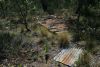
Site 4 - W-G BU4 Shed: Back in the truck the aircon was much appreciated. 0.5km further S we again stopped and walked to the E side of the Naas River, looking for BU3 John Macnamara's hut and BU4 Shed. I'm sure my companions allowed this visitor a bag of the very obvious pile of corrugated iron and shaped posts lying around. From the evidence, we decided BU4. Description: "300m north of BU3, on a raised soil platform 50m east of Naas River. Salvaged sawn and axe-cut timber, corrugated metal roof." Even though we searched at least 300m S and N, we found no hut site (it was reported as almost vestigial 30 years ago). (See pic 4).
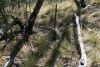
Site 5 - Hines' Hut site (from MH material): 270m further S we stopped, walked E across the Naas River and Lou led us directly to this site. Description included: Probably built 1900-1910. Pile of granite blocks." Indeed it was. (See pic 5).
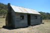
Site 6 - W-G BU1 1-3, Horse Gully Hut/SoS in the ACT G26: 3.5km S we lunched at Horse Gully Hut (see pic 6). First time I've lunched in the bush in an air conditioned truck - not that I'm complaining!
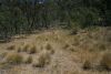
Site 7 - W-G BU1 3-3, Stockyard: For a change we headed N for 250m, back to the stockyard site on the W of the Naas Valley Fire Trail. Description is: "Immediately adjacent west side of Naas-Mt Clear track at entrance to grassy flat; 200m north of hut sites." (See pic 7).
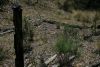
Site 8 - W-G BU2, Stockyard: 1.4km S, post number 18 on the Naas Valley to Horse Gully Hut brochure walk and a well graded water runoff led us to this site, so none of us could claim this bag. Burnt out of course, Keith surmised in the early 1983 fires. Description is: "In a timbered saddle with no visible landmarks; 20m west of Naas-Mt Clear track, contiguous with border of portions 14 and 32. Machine-sawn timber wire bound into post and rail." (See pic 8).
Site 9 - W-G BR8, John Brayshaw's two hut sites: 4.9km S we stopped and Keith shared with me the obvious (when pointed out - I must have walked past here at least 3 times without noticing) exotic fruit tress which marked this site. Description is: "About 100m north-west of ford across Naas Creek. Hut 1 - collapsed granodiorite and slate chimney, roof shingles and wall timbers. Hut 2 - soil marks and three lines of granodiorite. Hut valued at £45 in 1879, erected by john Brayshaw." (see pic 9a and pic 9b).
Site 10 - W-G BR4, Mt Clear Water Tank: 1.6km S (then backing up 160m!) we saw the water tank up on the hill. Wandered up to it. True to description, it looked concrete on the outside but was corrugated iron on the inside. A lovely shiny tap. Description is: "Wholly covered in cement. Height 2.1m Circumference 5.5m. Good order, about 80m south of track to Naas." (See pic 10).
Site 11 - We drove back to the NVC, stopping at the Tom Phillips site.
Thanks Keith and Lou - a great privilege and a mighty quick way to fill in some blanks. I hope you'll invite me again!