13-14 July 2013 Mount Scabby - Mount Kelly
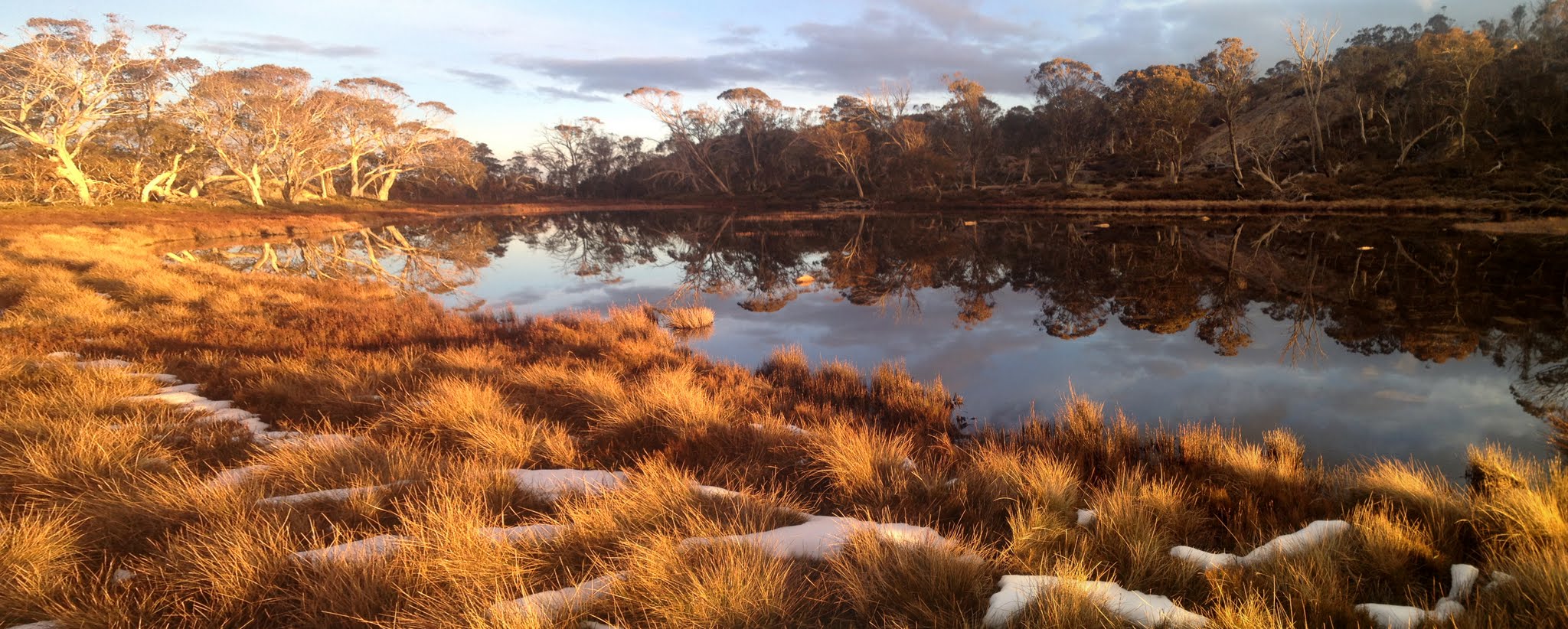 Scabby Tarn at sunset Maps: Yaouk and Rendezvous Creek 1:25000 Walk Description This walk was organised and led by Keith T as a CBC walk: Saturday-Sunday 13-14 July: Mount Scabby - Mount Kelly - L/R. Boboyan - Sams Creek - Mount Scabby - Mount Kelly - Boboyan. Expect some snow on the ground and a cold night. On the last three trips to this area in July, the overnight ambient temperature has been -10°C. If weather or snow conditions are unsuitable, this walk will be relocated or cancelled. If I don’t know about you or your walking ability you will be quizzed mercilessly about your walking experience. There will be an early start on Saturday morning (leaving Canberra at 5:30am) and on Sunday night there will probably be an after dark finish (about 6pm back at the cars). Please contact me if you would like further information. Maps: Yaouk, Rendezvous Creek. Leader: Keith T. Transport: ~$70/car. Limit: 8. 4 of us left town at 6am and drove to the Yankee Hat car park. Further Information Last times I went with Keith on this trip were 7-8 Jul 12 and 8-9 Jul 06. First outing for the new Kovea remote canister stove. Photographs Click here to access all walk photographs.Track Maps Track maps: thumbnails are active - click for a larger picture
Videos
Google Earth Track Notes A tough leader, a tough trip to fabulous destinations in adverse conditions - a ripper! Left Canberra at 6am. A black dog on the left going in the dirt to the Yankee Hat car park. Walking by 7.10am. A brisk pace indicating shades of things to come. 52mins for the 4.4km to the top of the open lead at the start of the Gudgenby Saddle footpad. Then another 52mins for the 2.5km to the Gudgenby Saddle. That's around day-walking pace. Another 1hr 5mins for the 3.8km down across the Naas Creek, around the S of Mt Gudgenby and across Sams Creek before Keith allowed us to break for morning tea. It was a partly cloudy day and cool, so just perfect for walking. A very cohesive party (we'd all been quizzed mercilessly about our walking experience) and a living legend navigator. We all took a turn at leading some of the time (although Keith did the hard work in the snow and scrub on Sunday). The next leg was up Sams Creek on the W side (true right) till we crossed the first major side creek. A combination of footpad and guess work - Sams Creek Fire Trail is no more in this area. We then bent away to the NW, climbing steadily up a spur through reasonably friendly scrub. We crossed the benching of an old vehicle track that Keith knew about at the 1580m contour, then finally gained the saddle area between the two knolls to the E of the Scabby Range. A few hundred more metres up the spur to the SW we stopped for lunch at 12 noon. This leg 3.5km in 1hr 35mins. Telstra reception, so was able to tweet a pic. Great views to the snowy hills all round. I was most grateful to Keith and the party for getting us to here by this time, as our fearsome leader announced that he planned to go all the way round the border to Mt Scabby and that there was plenty of time for border marker hunting. This, plus the final leg N to the camp site, has saved me a day on my planned border marker hunting trip to finish off the SW border. After lunch we sidled round the top of an unnamed arm of Sams Creek that flows down N then E to join it, then up the last 100m climb onto the Scabby Range crest at border marker P80. 1km in 30mins. We dumped our packs. The day, though still cloudy, was without a breeze and the sun beautiful. A wonderful loop followed, SW along the crest of the Range and around the bottom of the corner to Mt Scabby. We visited border markers O80, N80, M80, L80, K80, J80 and I80. Stunning views all round, highlighted by the sun and snow. We gazed down from the very source of our fine drinking water, the Cotter River. From Mt Scabby we returned directly to our packs across the top of the Cotter River. The loop was 2km and took 1hr 5mins. The final leg for the day was N along the Scabby Range crest, down to a saddle, up over a knoll, down to SH1618 and around the E side of the impressive bluff that overlooks the Scabby Tarn draining into the Cotter River. Border marker hunting, so the leg could normally be done a little quicker. 2hrs 10mins for the 3.1km, dropping off to the SE from the border to our camp site by the tarn. We visited the 41 Mile marker, Q80 with its concrete cylinder inside, Keith pointed out an extra marker, R80, S80 with its concrete cylinder inside, T80, U80, V80 and W80 (an impressive straight lockspit pointing up towards the Kelly Spur and with huge views across to the East Scabby Range). X80, positioned down in the swampy saddle at SH1618, could not be found. Visited Y80 with its concrete cylinder and nail exposed, but we didn't rearrange it. Could not find the 42 Mile marker. We walked across the drain of the tarn and caught our first view of this lovely place. Visited Z80. So ended the border marker hunting at 4pm - thanks Keith! Magical views of the Scabby Tarn as we walked its N edge round to higher ground to camp. I'd never seen it with water in it on my previous visits on 15 Apr 08 and 8-9 Jul 06. We set up camp. Adam, the lightweight freak, sat in his chair drinking beer whilst he watched the old fellas set up tents. Ron lit the fire. I took the opportunity to get my water at sunset and got some nice shots of the tarn. On an iPhone 4, never seen PhotoShop - so fortunate to be there at the right moment in the right light. Boot, socks and feet drying, dinner (remote canister stove burns strongly when you turn the gas upside down), to bed about 7pm as the mist began to swirl around. A warm night, minimum -2.6°C according to Keith's probing thermometer. Dulcet calls from the boss at 6.15am. Breaky, pack up and away at 7.30am. The weather was not so good, showers requiring shells. A bit more snow about, increasing as we climbed to Mt Kelly. A little ice on the SW spur to the top. The leg took us along the crest of the W Scabby Range, generally along the border but no time to stop and look for border markers. Cold and damp. 2hrs for the 4km, with careful going through the snow and over slippery rocks. No place to break a leg. I only came to bag the leader and the trig for the CBC 'Stretch Your Legs' events (grin) and this will be the toughest leader and the toughest trig to bag! The wind was bitter, it began to snow, the log book was sodden (as last time). However, the views were fabulous. No words do them justice and, even though there's a cost to get here, for a moment you're a soaring eagle rather than a flapping chook. Telstra reception, so was able to tweet a pic. We left a couple of minutes after 9.30am. Thankfully, all downhill from here. First, slowly down to Bogong Gap for morning tea. 1.8km in 1hr 10mins. Then, generally a straight line first down the S arm of Middle Creek, then onto the Burbidge spur to cross the S arm again near the junction with the N arm and so out onto the Gudgenby grasslands and back to the car. In all, 10.1km in 4hrs 25mins, including two lunch breaks. Some observations on this leg for my benefit, thinking about Brian S's proposed Kelly spur extended day trip in late October:
This really was a classic trip. The third time I've done it with this living legend (previous 7-8 Jul 12 and 8-9 Jul 06). I wonder if I've got the stamina at 65 to do it next year? Summary Distance: 36.6km Climb: 1500m. Time: 2 days. Walk Participants 4 walkers - Adam L, Ron S, Keith T (leader), me. Back to Walks Index This page last updated 3Sep22 |


