
26-28 February 2010 The High Country
Maps: Perisher Valley and Geehi Dam 1:25000
Getting There
This walk was organised and led by Philip G as an NPA/FBI walk:
Fri 26-Sun 28 Feb - THE HIGH COUNTRY - MEDIUM-HARD PACK WALK Leader: Philip G. The plan for this walk is to start from Charlotte Pass and take in some of Australia's highest peaks. Most of the walk will be off track, some of it will be scrubby and there will be rock scrambling. Each day will involve a total climb of about 800m. Contact leader for more details closer to the date. This walk is also on the NPA(ACT) outings program. Cars: 400km approx ($48). Limit of 8. Bookings close Tue 23 Feb.
Further Information
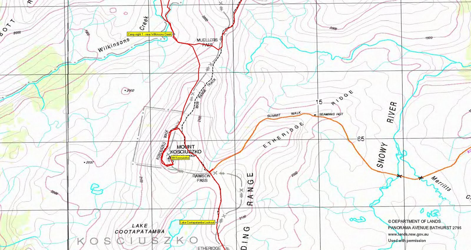
We'll leave a car at Guthega Power Station (Munyang). The walk will start at Charlotte Pass and follow Kangaroo Ridge south-west to the Rams Head Range, up North Rams Head then onto the main peak. We'll then descend to Cootapatamba Hut and Lake and continue north across Wilkinsons Creek (where, depending on timing, we may spend the first night) and onto Abbotts Ridge and Mt Townsend. Beyond Mt Townsend we'll follow the ridge to Muellers Peak, Mt Lee and onto the track across Carruthers Peak, then off the track to climb Mt Twynam. We'll then go north along the Great Divide to the Rolling Ground for the second night. On day three we'll walk along the Rolling Ground to Whites River Hut then down to Munyang via the Aquaduct Track. This is about 50 kilometres and involves quite a lot of up and down but no significant climbs. There should be time for one or two side trips. This plan may change if the weather looks ugly.
Getting better - left home with 12.4kgm (incl 3l of water) + day 1 lunch.
Walk
|
| Track overview |
Kaz reckons that this is not a bad track to have as, from Rawson Pass to the Munyang-Geehi Road, it marks the 'official' unofficial AAWT through The Main Range.
 |
 |
 |
 |
| Day 1 Charlottes Pass to Mt Stilwell |
Day 1 Mt Stilwell to Merritts Creek |
Day 1 Merritts Creek to Rams Head Range |
Day 1 Rams Head Range to Wilkinsons Creek camp |
 |
 |
 |
 |
 |
| Day 2 Wilkinsons Creek to Mt Townsend to Mt Lee |
Day 2 Mt Lee to Mt Tywnam |
Day 2 Mt Twynam to Mt Anderson |
Day 2 Mt Anderson to Mt Tate |
Day 2 Mt Tate to The Rolling Ground camp |
 |
 |
 |
| Day 3 The Rolling Ground to The Granite Peaks |
Day 3 The Granite Peaks to Whites River Hut to Disappointment Spur Hut |
Day 3 Disappointment Spur Hut to Munyang |
Day 1
We shook ourselves out and left Charlottes Pass just after 10am. It was a beautiful blue-sky day. A newly refurbished walking track took us past both old and new ski lift stations above Charlottes Pass. Then a well worn footpad to Mt Stilwell. I later discovered that my GPS had been accidently switched off, so the track photo above from Charlottes Pass to the cairn on the NE end of the Rams Head Range (cairn 2) above Merritts Creek is actually from 16 Apr 05. However, the rock frame feature and the beehive shaped cairn are classic features and I have photos of these places from both walks, so the estimated track is pretty true. Kangaroo Ridge is a lovely area. A clear view to the Summit Walk snaking onto Etheridge Ridge and Mt Koscuiszko.
 |
 |
 |
 |
 |
| Old ski lift station above Charlottes Pass | Milling about at Mt Stilwell trig | Rock frame on Kangaroo Ridge | 1 Beehive shaped cairn on Kangaroo Ridge | The Summit Walk and Mt Koscuiszko from Kangaroo Ridge |
Passing the cairn, the little tarn near SH1959 attracted our attention. Around halfway between here and the Koscuiszko Walk we stopped for lunch, as 12.45pm had struck. A delightful little tinkling waterway. From here we continued generally SW to intersect the Koscuiszko Walk at Koscuiszko Lookout. I don't believe that I've seen this wonderful steel walkway before. Today it was well used, including by a large school group. Crossing the Walk we headed up to the ridge, the views to Rams HEad Range taken at around the 2100m contour. Absolutely beautiful walking on mountain grasses. Arriving at the foot of Rams Head North, we dropped packs and climbed to the granite at the top to arrive at 2.30pm. Back down we skirted around its N, then headed along the range to the next knoll marked with a TV aerial-like affair. The Rams Head top lay a further 700m away to the SW, but with still a way to go we could not afford the return journey to it.
 |
 |
 |
 |
| Cairn on the NE end of the Rams Head Range | Views to Rams Head Range | Party members on Rams Head North | Rams Head from the knoll |
Back to near Rams Head North we swung N along the ridgeline and rejoined the steel track at Etheridge Gap. Around 400m N we came to Cootapatamba Lookout. Views to the lake and the red survival shelter down the Swampy Palin River. A further 800m took us to Rawson Pass. I was very pleased to not only inspect, but put to good use, the grand underground toilets. The latest style in industrial looking stainless steel, very clean and odour free. Sweet relief! Ran into a contractor collecting grass seeds. Regrouping, we went on a hundred metres or so and the majority of the party continued on to the top of Mt Koscuiszko, arriving at 4.50pm. A whole lot better view than on my previous 9-10 Apr 05. Brian pointed out the nearby site of ?'s weather station.
 |
 |
 |
| Lake Cootapatamba | Koscuiszko Walk towards Etheridge Gap | 2 Abbott Peak, Mt Townsend and Muellers Peak from Mt Koscuiszko |
Regrouping again, we headed N along the ridge top towards Meullers Pass, paralleling the Main Range Track. With Wilkinsons Creek in view we peeled off down to the idyllic camp site, arriving at 5.50pm. A beautiful spot.
 |
 |
| 3 My Tarptent Moment under Mt Townsend (2nd highest hill in Oz) in Koscuiszko National Park Australia | Sunset at Wilkinsons Creek camp site |
Day 2
The day dawned clear, but cloud soon shrouded the mountain tops.
 |
 |
| Sunrise at Wilkinsons Creek camp site | Clouds fly fast over Abbott Ridge |
Leaving at 8am with day packs, we headed N up through the arms of the top of Wilkinsons Creek to Mt Townend. We scrambled to the top from the NE side, the cloud base happily rising above us to allow all round spectacular views. Wonderful view NE along Abbott Ridge to Alice Rawson Peak, near which I'd camped on my first visit to the Main Range on 9-10 Apr 05. Kaz spent a bit of time looking for a cave amongst the granite near the peak and was absent from the group photo. Back down at the base, a few of us took turns sitting atop the unique granite balancing pile - thanks for the photo, Kaz. We headed off SE towards Meullers Peak, then S to talk to one of a party of others who'd camped the night above us on an arm of Wilkinsons Creek and so back to gather our gear. Then 100m back up the old vehicle track onto the Main Range at Meullers Pass.
 |
 |
 |
| Mt Townsend at the head of Wilkinsons Creek | Alice Rawson Peak from Mt Townsend | 4 John atop the granite N of Mt Townsend (photo courtesy of Karen Cody) |
Here we joined the numerous walkers doing the Main Range Track, as the cloud base unfortunately lowered. It did allow glimpses down to Lake Albina and Club Lake, but in the chilly mist all there was to do was to walk hard to keep warm. We managed the 4.4km to Carruthers Peak in 1hr. A quick bite of morning tea in the lee, then down to the junction of the Main Range Track and the old vehicle track to Mt Twynam. Down here the sun was shining.
 |
 |
| 5 Lake Albina from The Main Range Track | Club Lake |
A quick bash of 2.8km in 40mins towards Mt Twynam. As we approached it became a real pea-souper. I was out in front, in fact walking with another party of 4 guys, when things closed in. It was easy enough to follow the old vehicle track, but as it began to lose height I got a bit suspicious, so waited till the rest of our party arrived. It was a great reminder of how difficullt navigation can be in such conditions and of how quickly the weather can change. There was some examination of maps and GPSs, but in the end Max had the solution - walk up! So the point to turn off the vehicle track and head up the spur to the Mt Twynam summit is marked by a small cairn - a handy thing to know when visibility is reduced. We stopped briefly at the top - little to see. The other party left us - they were map and compass equipped, but it would be no small matter to descend to the cairn (we wondered at various times during the day as to how they fared). We came off Mt Twynam to the NE, then back to the NW and picked up the vehicle track. Lunch at 1pm, by which time we could see, but it was still overcast.
Fortified, we continued NE along the Main Range, using the vehicle track/footpad. W of Mt Anton, S and E of Mt Anderson (where the vehicle track ended), E of Mann Bluff, E of Mt Tate with a quick summit into the cloud and wind - no view, and on to Consett Stephen Pass for arvo tea. This leg, from lunch to arvo tea, 7.5km in 2hrs 45mins.
 |
 |
| Mt Twynam | Mann Bluff |
At last the cloud base was lifting and breaking up as we went E from CS Pass to skirt SH1993 and N onto the S end of The Rolling Ground. Another wonderful camp site.
 |
| 6 The Rolling Ground from camp night 2 |
Day 3
An hour of medium-heavy rain during the night tested my single skin Tarptent. A little internal mist, but not enough to wet sleeping bag or anything. The day dawned misty, but began to clear around 7.30am.
 |
 |
| Morning day 3 at The Rolling Ground camp site | Mist over The Rolling Ground |
By 8.30am we were 1.5km to the N on SMA0691, the southern most of The Granite Peaks. Views S to Watsons Crags and N to Dicky Cooper Bogong. 0.8km further N we topped SMA0112. From here, to the NE, we could see the knolls which marked the drop off point to Whites River Hut.
 |
 |
| 7 View NE from SMA0691, The Granite Peaks | 8 Marker knolls at 1900m contour for drop off to Whites River Hut |
So ENE we went, skirting the knolls to the S and E, and so down the spur to the hut. Heaps of people there - at least 3 parties. One large party with 2 vehicles was about to leave after doing hut maintenance. They kindly directed us to their fire which they were about to extinguish, so we were able to have a cuppa. Another party headed off SW up the fire trail paralleling the creek we'd crossed to basically do the walk we'd done in reverse.
We left Whites River Hut at 11am and bashed the Munyang-Geehi Road then Aquaduct Track to Disappointment Spur Hut for lunch. 4.1km in around 55mins.
 |
 |
| 9 Whites River Hut | Disappointment Spur Hut |
After lunch, a further 4km took us to Munyang (Guthega) power station and the lads completed the car shuffle.
 |
| Munyang (Guthega) Power Station |
Terence Uren's Light-Pack Bushwalking data was of assistance in deciding what to take, but I'm glad I took more than his allowance of 6 sheets of toilet paper per day!
A magnificent high country walk with a range of weather, thanks Philip. And to Brian S, Jacqui R, Jan G, Karen C, Max S and Trevor L.
Distance: 55.1km Climb:1700m. Time: 3 days
Grading: L/M; H(12)
KMZ file for Google Earth/Maps: The High Country
Back to Walks Index
This page last updated 15Aug22