
13 March 2012 Back to Two Sticks Hill and Sherwood
|
| 43128.7 links marker - Two Sticks Trig |
Map: Cotter Dam 1:25000
Getting There
This walk was organised and led by me as an irregular CBC Tuesday walk:
Tuesday 13 March - Back to Two Sticks Hill and Sherwood - L/E-M,ptX. My ACTPLA contact tells me the Two Sticks Hill location may well be misplaced on the 2nd edition Cotter Dam 1:25000 map; it’s not marked on the first edition map and it doesn’t line up with Percy Sheaffe’s field note book. In addition, I missed the graves/plaque at the Sherwood site which I visited on my first ever walk in 2001. Anyone know where the site is? As the combined Tuesday/Wednesday walk near Bundanoon has been cancelled due to water levels, I’ll return to Two Sticks Hill and Sherwood areas on Tuesday 13th. Around 16km and 500m climb. Map: Cotter Dam. Leader: John Evans - jevans@pcug.org.au, 0417 436 877. Transport: ~$8 per person.
4 of us met and drove to the locked gate at Blue Range Hut.
Photographs
You can access all photographs here.
Walk
| Track maps: thumbnails are active - click for a larger picture | ||
 |
 |
 |
| Track overview | Track 1 | Track 2 |
A nice early Autumn day, overcast at first then clearing to a warm 27°C (forecast for Canberra). A bit sunny around the N end of Two Sticks Hill on Two Sticks Road, but it was all over by 12.30pm, so no sweat.
An uneventful wander in to the Sherwood historic site, except that I missed the junction at GR671456-6093399 (MGA94), where the major fire trail continues NE (unmarked on both 1st and 2nd edn Cotter Dam maps)to join the marked loop. The straight fire trail over the shoulder of the rise would be more direct and a little shorter.
On the fire trail SE of Sherwood, the washed away culvert that swallowed Max last Tuesday was still unrepaired (and probably will be for some time) and we crossed a metre or two upstream on Linda's rubbish bin lid. We headed straight up to the seat and sign visible from the fire trail.
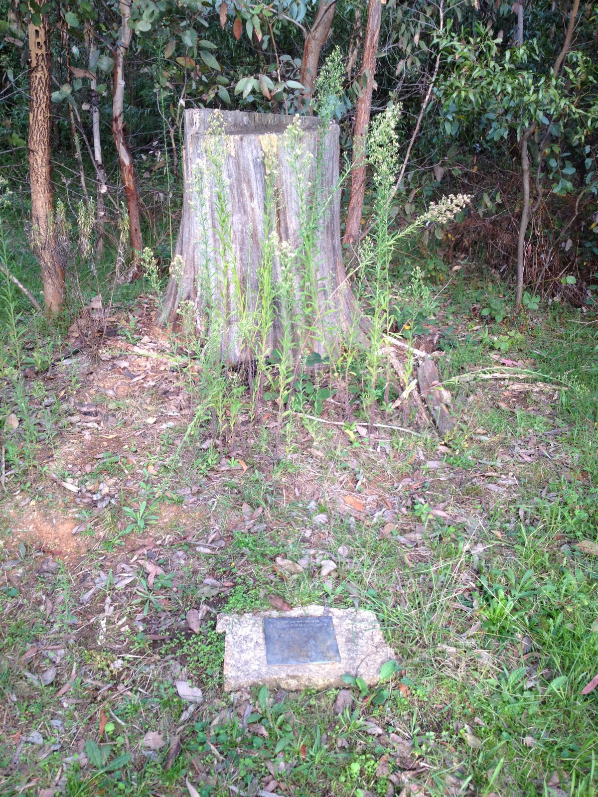
Thanks to Brian S's clue since last Tuesday, which was "The oak tree was burnt in the 2003 fires and was lopped so that only a high stump remains. There is a wooden garden seat just in front of the graves, which are marked by a plaque" I quickly (for my age) realised that the seat Brian referred to was the seat I'd visited last Tuesday. Lifting my gaze a mere couple of metres, there was the high stump with the plaque below. Golly, I am stupid.
However, in my defence, the are has changed dramatically since my first visit on 29 Apr 01. Prior to the fires, the fallen leaves from the oak tree kept the ground around bare and, of course, the 2003 fires ravaged the area. Here's now and then pics:
| Images below are large thumbnails - click for full sized picture | |
 |
 |
| Grave site and plaque 13 Mar 12 | Grave site and plaque 29 Apr 01 |
The plaque says:
This plaque was erected on
2 November 2000 by descendents in
memory of
HENRY PHILLIPS
27.4.1823 - 28.1.1913
ELIZA PHILLIPS (nee DOVE)
23.7.1838 - 14.12.1922
and their infant son HENRY (1878)
who lie buried here at 'Sherwood'
The walk I did on 29 Apr 01, was led by my mate Stan L as a church walk and it's described in Graeme Barrow's book 30 Family Bushwalks in and around Canberra, Dagraja Press Canberra 2002. I hope Graeme doesn't mind me lifting a couple of relevant paragraphs:
"Next to nothing remains of the 19th century homestead that postmaster Henry Phillips built at his property , Sherwood, beyond Blue Range Camp in Uriarra Forest. ... Many thousands of daffodils flourish at Sherwood in springtime (they are at their best in the first two weeks in September) and various fruiting trees and other exotics can still be seen. But a few stones, used to support a fireplace, are all that is left of the homestead. Describing the property in its heyday, a regular visitor, Emily Walker, wrote: "There was a delightful flower garden, fruit trees laden with cherries, apples, walnuts, raspberry bushes, red currents..." On Ropers Hill, overlooking the site, lie Henry Phillips, his wife Eliza, and an infant son, also Henry, who died in 1878. A massive oak tree and a wooden fence mark the location of the graves, but those interred here have no headstones. A memorial plaque set in stone was unveiled in November 2000."
With the spring of achievement in my step (something about small things and small minds), we wandered down to the Sherwood site and had a poke about. The other lads hadn't seen it.
Leaving via the fire trail heading NW, we did the switch-back onto the ring road round the 2nd edn map-marked Two Sticks Hill, headed N, then NW up the steep climb to the saddle between the southern 'Two Sticks Hill' feature and the northern 900+m feature.
Here we turned NE and sidled through open forest with a bit of scrub and fallen timber back to the border. After a bit of mucking about (is my GPS affected by my iPhone which I carry near to it for use as a camera?), we came upon Percy Sheaffe's marker at 43128.7 links from Mt Coree, which he labelled "Two Sticks Trig" in his field note book A 69 - Coree to CH48,000 - FC18 sheet 1 - (PDF 14.0 MB). Here's the page image:
| Image below is a large thumbnail - click for full sized picture | |
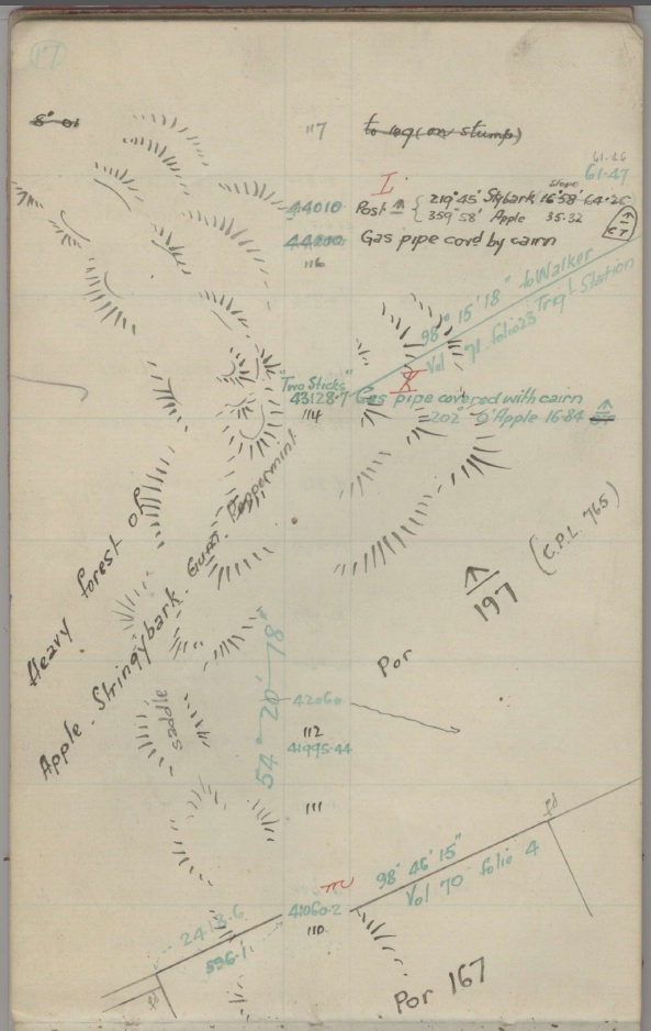 |
|
| Two Sticks Hill area from Sheaffe's notebook A 69 - Coree to CH48,000 | |
We couldn't find the "Gas pipe covered with cairn", but there was a healthy lockspit. The Apple [box] at 202°0' and 16.48 links was no more. So this confirmed Alex P's advice since last Tuesday that "You are correct that the mark called “Two Sticks” is north of the hill labelled as such on the map. This is the first time the name has appeared on a NSW topo map, not being on the earlier 1972 1:25,000 edition (or any other preceding map). I suspect that the hill labeled as such is incorrect, and it might be the peak to the north of the trig." and "When that section was re-marked during 2004-05, some surveyors would have used hand-held units to get within cooee of the marks. For that purpose, a WGS84 fix would have been close enough for visual discovery."
Maybe the twin peaks, the one we visited last week and the one we visited today are the twin peaks of Two Sticks Hill?
Although only 9.30am, I revealed my compassionate nature by suggesting we could have morning tea. Eric suggested trying to find a better view, so we headed N-ish towards the top ridge of the feature. The first knoll offered an open, bare area in the light timber, so we sat down to munch.
Next we went E-ish and relatively steeply down through scrubby, dry bushes and light timber to find the 44000 link marker. Now just a lockspit, Percy originally described it as "Gas pipe covd. by cairn". No sign of the Post and nearby blazes 10 links further on.
We continued NE down along the border, the going down easing as we broke from the timber - onto private land. No sign of the 45085.52 and 46336.5 links markers. They were originally "Peg"s and would have rotted away or been burnt by now. The border here was a new fence separating the NSW and ACT properties - sorry folks, I didn't know we'd be on your land for a few hundred metres.
Down at Two Sticks Road where the border crossed it, there was a fine set of pillared gates. The marker for 48000 - Six Mile CB is located there and I thought it would have been disturbed by earthworks, but there was a small lockspit (perhaps refurbished in 2004-05), just on the edge of the fire trail disturbance and by the wire fence.
Warm in the sun as we wandered Two Sticks Road, got too near another private house, cut a loop of TSR and came round the N end of today's Two Sticks Hill. Shady as we got round the W side of the hill. Thanks to Ian's vigilance at a junction where I began to head NW further along Two Sticks Road and would have added a further 5 or 6km to the ramble, we continued southwards.
At 4 or so km from Blue Range Hut, we decided to press on to there for lunch, reaching that location at 12 noon. Again, the lads appreciated the historical signage. We lunched at a shaded bench. I took a little wander across the creek to see if I could locate the original footpad I used on 29 Apr 01. No luck - much changed since the fire. Back to the car. Home by 1pm - don't tell anyone I'm getting soft.
Stopped at the Cotter Pumping Station on the way back and wandered down by the bridge to the venturi pipe discharging water (from where?) at the confluence of the Murrumbidgee and Cotter Rivers.
Mike S, an ex ACT water man says: "... if this discharge is upstream of the bridge it’s a scour from the Bendora water pipeline to help remove iron and manganese scum build up in the pipe but I thought this arrangement we built many years ago was no longer used due to river pollution problems."
Thanks Eric G, Ian W and Phillip S. A pleasant stroll. And some minor puzzles solved.
Distance: 16.1km Climb: 500m. Time: 7.30am - 12.30pm (5hr), with 35mins of stops.
Grading: L/E-M,ptX; M(10)
KMZ file for Google Earth/Maps: Back to Two Sticks Hill and Sherwood (the border's a bit out on Google Earth!)
Back to Walks Index
This page last updated 29Aug22