This walk was organised and led by me as an irregular Tuesday walk:
(Tuesday 18 March - Southern Namadgi European Structures including Lone Pine Homestead and Tin Dish School - L/E. A circuit in the southern Namadgi National Park to visit a number of sites of European settlement. From the Old Boboyan Road South car park, wander to the Boboyan Homestead ruin, then via the Grassy Creek fire trail to the Lone Pine Homestead ruin. Cross country down Grassy Creek brings us to Waterhole Hut and Yards, then further on to another set of yards. Back on the fire trail we visit Westermans Hut and Graves, then to Brayshaws Hut near the Boboyan Road. Across the road from here we visit the site of the Tin Dish School, then tromp back to the car. Around 21km and 350m total climb. Maps: Yaouk and Shannons Flat. Leader: John Evans – jevans@pcug.org.au, (h) 6288 7235. Transport: ~$14. Further details at http://jevans.pcug.org.au.)
4 of us left Canberra at 7am and enjoyed (endured) the long drive to the Old Boboyan Road (South) car park.
See http://www.waymarking.com/waymarks/WM25K2. 55H E 679342 N 6027947. Across the road from Brayshaw's hut, are the ruins of an old school house. Known locally as the Tin Dish School, and officially as the Bobeyan Subsidised School, it was a small one roomed structure of weatherboards and iron. It was built by local parents from materials from another school. Only squared blocks of grey stone from the fire place remain. it opened for first term of 1907, operated for four terms of 1908 and 1909, then closed at the end of the first term in 1910. William Gottaas was the teacher. Children from the Dwyer, Perry, Weterman and Chalker families attended, as their holdings were along nearby Grassy Creek.
I've been through the area before (neglecting to photograph the Lone Pine Homestead site and visit the Westermans Graves and I didn't know about the Tin Dish School site then) on 8 May 07.
With new information available to me, let's have a good look for:
On the way there, at the bridge over the Gudgenby River near the Naas property, Michael Herbert Cairn. 30m downstream from the bridge may be the Naas Ford and Flying Fox.
Brayshaws Cairn; Boboyan Homestead - 1901 site + 1866 site, 4 sheds, dam, chicken coops, well/spring, graves, fence, orchard, stockyard, cultivation paddock; Bridges over Naas Creek; Fork fence and gatepost; Alexander Brayshaws hut site; 2 Fork fences; Lone Pine Homestead site; Waterholes Yards; Waterholes Hut; Yards; Westermans Hut and Westermans Graves; Tin Dish School; Brayshaws Hut, Brayshaws Shearing Shed, Brayshaws Fencing; Stockyard and Fork fencing.
Route Card
| Southern Namadgi European Structures including Lone Pine Homestead and Tin Dish School | ||||
| Leg | Description | Distance (km) | Expected Going/Comment | Est time and looking (hr:min) |
| 1 | Scout around Gudgenby River bridge at Naas for Michael Herbert Cairn, Naas Ford and Flying Fox | 0.1 | 0:15 | |
| 2 | Start to Brayshaws Cairn | 1.1 | Old Boboyan Road (South) | 0:30 |
| 3 | To Boboyan Homestead ruin and look for both sites, sheds, orchard, stockyard, cultivation paddock, coops, well/spring, fence | 1.1 | Old Boboyan Road (South) | 0:30 |
| 4 | To Graves | 0.2 | Light timber | 0:15 |
| 5 | To Bridges over Naas Creek | 0.6 | Creek flats | 0:15 |
| 6 | To Fork fence and Gatepost | 1.0 | Grasslands | 0:30 |
| 7 | To Alexander Brayshaws hut site | 2.0 | Grasslands and fire trail | 0:45 |
| 8 | To Fork fences | 1.0 | Fire trail | 0:30 |
| 9 | To Lone Pine Homestead ruin, | 1.0 | Old Boboyan Road (South) and Grassy Creek Fire Trail | 0:30 |
| 10 | To Waterholes Yards and Waterholes Hut | 5.9 | Grassy Creek Fire Trail and along Grassy Creek | 2:00 |
| 11 | To next Yards | 1.2 | Along Grassy Creek | 0:30 |
| 12 | To Westermans Hut and Graves | 2.1 | Grassy Creek Fire Trail | 0:30 |
| Lunch | 0:30 | |||
| 13 | To Tin Dish School | 2.0 | Open woodlands | 0:45 |
| 14 | To Brayshaws Hut, Shearing Shed and Fencing | 0.5 | Open grasslands | 0:30 |
| 15 | To car via Stockyard and Fork fencing | 2.2 | Boboyan Road | 0:45 |
|
Totals |
21.9 | 9:30 | ||
Walk
The day dawned to reveal a perfect blue sky. Just a touch of autumn cool in the early morning, with mist rising from various water and creeks. But it promised to be hot, with 31°C forecast for Canberra. It turned out that Canberra enjoyed 29°C and we had a slight breeze most of the time to remove the fierce sting from the sun.
First stop was the bridge over the Gudgenby River at Naas to view the Michael Herbert monument (see pic 1). A site that one drives past often, but in a hurry to get somewhere in the morning and too tired to stop on the return trip. So a planned stop. It is said that the actual grave lies under the current road. We wandered a few tens of metres downstream to identify the overgrown Naas Ford (see pic 2), but there was no sign of the Flying Fox.
Back into the car to continue the drive south. We arrived at our start point at the gate on the Old Boboyan Road (South), having turned off the Boboyan Road to the right around 1km past the Mt Clear camping ground turnoff on the left.
Away along the road, easy walking, and a delight to find our first historic site, David Brayshaws cairn (see pic 3), where it was supposed to be. Signage at Brayshaw's Hut tells the story:
In August 1931 David met a tragic end while riding home from nearby 'Bobeyan' where his brother lived. He left after lunch but didn't arrive home that evening. Two days later his riderless horse was found with David's body lying nearby. Stirrup irons were still on his feet and his hat and whip were on the ground nearby. He had died from exposure. Today the place is marked by a small pile of white rocks. David was 79 years of age.
Back on the road we spied the first of 7 wedge-tailed eagles, soaring close by. Its mate was sitting in a tree nearby. On to the Boboyan Homestead site (see pic 12). Previously I'd only known about the obvious stone chimney but with new information available to me, we were able to identify the original 1866 cottage site, the dam on the creek, the spring (no sign of the well), fencing and the orchard. One could only guess at the locations of the coolrooms, stockyard and cultivation paddock. Forgot to look for the coops. We headed away from the homestead complex to look for the unmarked graves, but were not able to spot them.
Our next objective was a reported pair of bridges across the Naas Creek. One, in fact, is marked on the 1st edition Yaouk 8626 2N 1:25000 map. We headed north across the road and soon spied uprights down at the creek. The bridges, of course, are gone, but some uprights and the granite-blocked approach are still there at bridge 1 (see pic 4) and, a few tens of metres downstream, some timbers of bridge 2.
Back onto the road for a little way, I was looking for the junction with an old track, again marked on the 1st edition Yaouk 8626 2N 1:25000 map, which was to lead us to some old fencing. Nothing could be identified.
So back to the road and so to the intersection with the Old Boboyan Road and the way ahead becoming Sams Creek Fire Trail. At this stage we were looking for Alexander Brayshaws hut site and spied a feature (a metal rod cemented in a pile of granite) in an area which suited the information we were working from (except the GR). We mused for a while, thought maybe, then headed off along the close by fire trail. Abysmal navigation by me, although I did get a little uneasy as waypoints on the GPS which should have been straight ahead started to swing round towards right angles! A pause in the shade and breeze for morning tea, as we'd covered 6.6km in 2.5hrs.
We continued on for a tick, but unease grew to alarm, so a halt was called and the GPS oracle placed us around 2km east of where we should have been. Retracing our steps, I realised we'd headed down the (unmarked on 2nd edition map) Bulls Flat Fire Trail. There's also differences in nomenclature between the map and signage on the ground as to what the northern part of the fire trail we wanted is called. Map calls it Grassy Creek Fire Trail at this point, signs call it Sheep Station Creek Fire Trail.
Anyway, another similar knoll appeared with - according to script - a quince tree on the north facing side. There, lo and behold, was the obvious granite flagging of Alexander Brayshaws hut site (see pic 5).
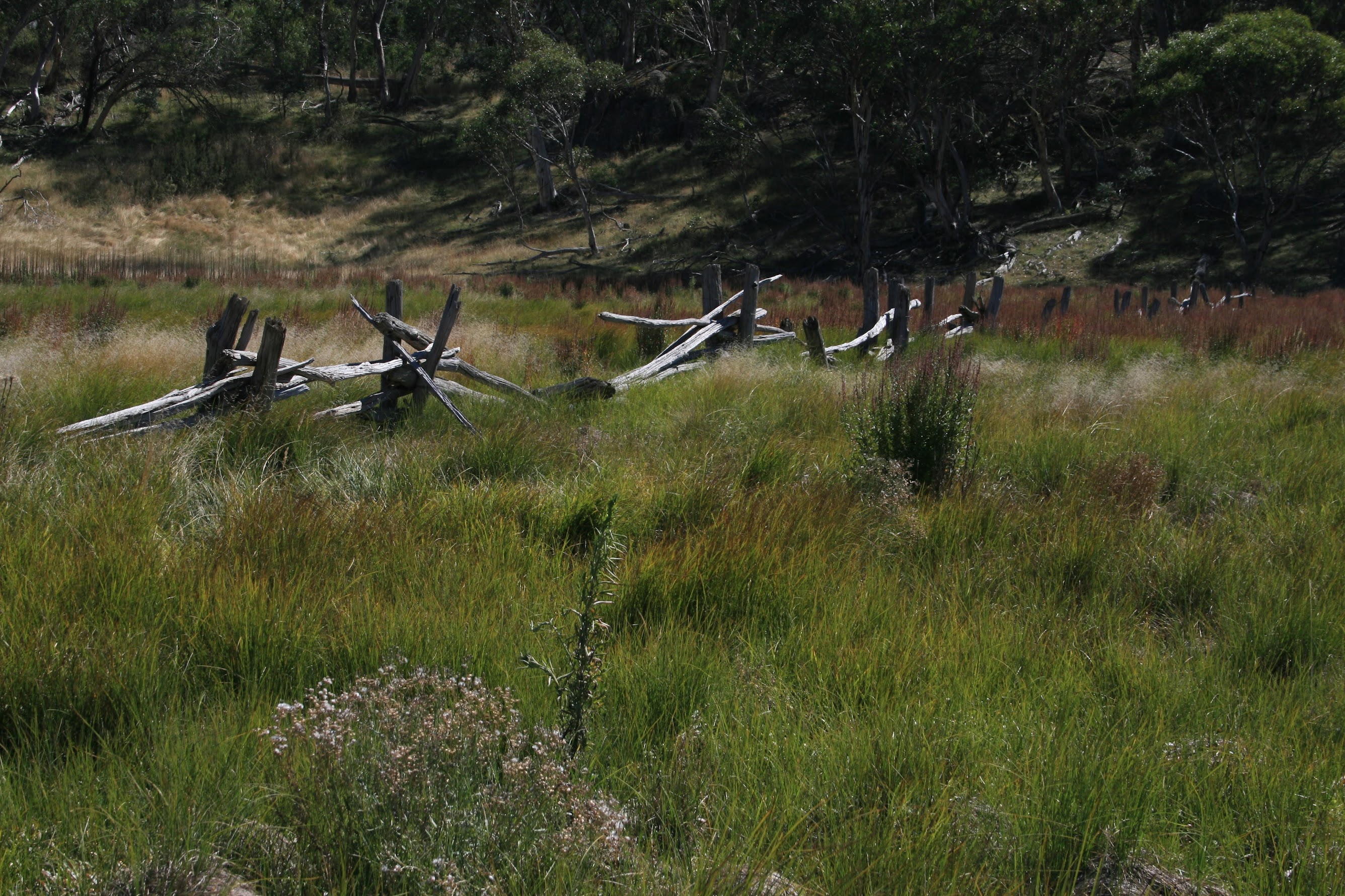
The next site was already in view - a line of fork fencing marching across Sheep Station Creek (see pic 6). Nearing it, a parallel line of similar fencing was seen around 40m further up the creek.
1.3km along the fire trail we came to the Lone Pine Homestead ruin. Marked by a large stand of exotic trees and a small sign post, we entered the area and I photographed it this time (see pic 7). We circumnavigated the site and the lightning blasted 'lone pine' was seen lying on the ground.
Away and Dick immediately saw the flash of something on our left. A small brass plaque glued to the face of a block of granite reading:
'In Memory of Baby Crawford Infant Son of Dalla and Dan Died 13-6-1915'.
We continued following the fire trail generally south. We passed signage informing us that the Bulls Flat Fire Trail (the one not marked on the 2nd edition map) was joining us on the left. Hot in the sun.
At Grassy Creek we did a left turn and followed the creek line (the occasional stagnant pool of water) generally SE. Followed an old cart track for 30m. Clever navigation (watching the GPS arrow) got us to Waterhole Hut Yards (see pic 8). Informative signage there which says:
'These stockyards were built by Jack Oldfield and Alf Peters during the period 1935-39. They were used to contain both sheep and cattle and represent one of the most intact examples of pre-World War 2 stockyards in Namadgi National Park and perhaps in the Australian high country'.
100m further on we found lunch for 30mins at Waterhole Hut (see pic 13). Interesting to see that huts are now fitted with fire extinguishers.
On down Grassy Creek we next came to the stockyards near Pheasant Hill (see pic 9).
From there, back to the (now correctly named) Grassy Creek Fire Trail and wandered along to Westermans Hut (see pic 14). A look around and inside (very well restored) and easily found the graves around 150m to the south (see pic 10). The inscription on the plaque reads:
'In loving memory of Elizabeth Mary Shiels loved daughter of Thomas & Mary Jane (nee Perry) Westerman 21.10.1876-26.7.1922 also her brother Baby Westerman died 1886. Erected by her relatives Jim Crawford, Dolly Oldfield and Bill Osmond. 1991. RIP'.
From the hut we wandered NE towards the Boboyan Road. Saw the roof of Brayshaws Hut to our left, crossed the road and Chris found us the Tin Dish School ruin once the GPS said we were close (see pic 11).
Back across the road and to Brayshaws Hut (see pic 15). A wander around looking for the shearing shed site which we think we found, based on the information we had.
A wander down the drainage line to the N, looking for various fences and yards. However, late in the day and being 'fenced and yarded out', I did get a bit casual. Back onto the road, our steps took us back to the car.
Everyone seemed pretty pleased with the day. I certainly was, in being able to visit a few sites not immediately obvious. Thanks for your company Brian, Chris and Dick.
Distance: 24.1km Climb: 350m. Time: 8.30am - 4.40pm (call it 8hrs) with 35 mins of stops and adequate site visit time.
Grading: L/E; M(10)
KMZ file for Google Earth/Maps: Southern Namadgi European Structures