

2 October 2011 Camels Hump and Pierce Trig - bushwalking promotion
Map: Tidbinbilla 1:25000
Getting There
This walk was organised and led by me as a CBC walk:
Sunday 2 October – Camels Hump, Pierce Trig and beyond - bushwalking promotion - L/E-M. Camels Hump and Pierce Trig via the Camel Back fire trail. Possible other objectives in the Jedbinbilla area, dependent on car shuttle. An opportunity to do a radio interview on ABC 666 radio at 10.45am to promote CBC/50 Peaks in 50 Weeks, bushwalking in general and Johnny Boy's Walkabout Blog. Around 15km and 800m climb. Map: Tidbinbilla. Leader: John Evans - jevans@pcug.org.au, (h) 6288 7235. Transport: ~$8 per person.
4 of us drove to the Tidbinbilla Nature Reserve. Gates open at 7.30am. We drove through and on up to the Mountain Creek car park.
Further Information
Must be at Mt Gingera by 10.30am, for a 10.45am interview. To talk about 50 Peaks in 50 Weeks, the route to Mt Gingera and the view, bush walking in general, Johnny Boy's Walkabout Blog, CBC. Timings would be:
5.30am - leave Canberra - 30min drive to Corin Dam
6.00am - start walk - 3hrs 45mins is my best time, allow a 45min leeway, give arrival at Mt Gingera at 10.30am. If the time is slipping away, the rest of the party will have to allow me to leave them, once we've gained the Mt Franklin Road.
Tested mobile phone communication on 28 Jun 11, a very blue sky, still day. Fall back sites, if weather/comms no good, could be Camels Hump or Mt Tennent.
This could be a good trip for walkers wanting to try the first leg of the 24-hr long long time walkabout.
I think we'll make this a champagne (and apple juice) brunch with croissants and raspberry jam, crackers and brie and neenish tarts.
Plan B is to do Camels Hump - now in operation. TNR gates open 7.30am; close 8.00pm. 6.4km in 2hrs 30mins on 30 Jul 11.
DAYLIGHT SAVINGS TIME!
Things to do - Camels Hump, Pierce Trig, going down Spur 3 look for track seen on Google Earth, Nil Desperandum area (Nils, euc still, camellia garden, weir), Ashbrook site, new or washed out bridges over Tidbinbilla River.
Photographs
You can access all photographs here.
Walk
| Track maps: thumbnails are active - click for a larger picture | ||
|
|
|
| Track overview | Track 1 | Track 2 |
The car shuttle didn't quite work out, so we were set for a there and back day (anyway, we'll cover the full route on the Worn Boot Bash on 29 Oct 11). An overcast day, with showers and 30km/hr winds forecast, but we managed to get home dry.
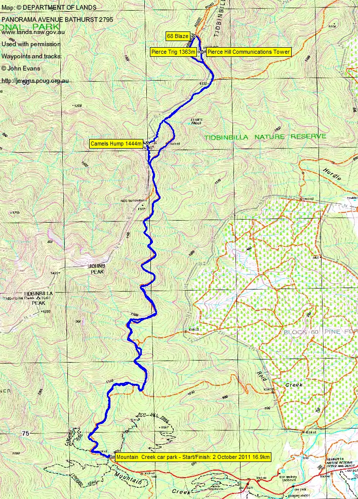
A steady wander up the Camel back fire trail to the base of Camels Hump, 6km in 1hr 40mins. The last 330m along the ground, up the spine of Camels Hump to the top, took 30mins. So were were there at 9.50am. The total climb is from 890m contour to the top at 1444m = 554 vertical metres.
THERE'S A BIT OF A SCRAMBLE UP THE SOUTH SPINE OF CAMELS HUMP, SO I'D RECOMMEND THAT NEW WALKERS NOT DO IT ALONE. PLEASE NOTE MY Disclaimer, Warning and Advice.
We popped the champagne (the lads did a great job as cork catchers), enjoyed the neenish tarts (and biscuits and 'bert) along with Sal and Jenny's mocha coffee. Got the phones organised, called home and, with Tim the Yowie Man in full control, talked up the Canberra Bushwalking Club and the 50 Peaks in 50 Weeks event.
We left at 11am, heading down the gentler N face to rejoin the Tidbinbilla Range Road. On to Pierce Trig for a look down to the East. Back down to the Road to view the blaze on the tree at the intersection. Thanks to my mate Barrie R for identifying the photo of the Purple Eyebright, Euphrasia collina, at Pierce Trig. I often send him a 'Wot flower is that' email after a walk and he never fails to identify.
We turned about and came back the fire trail to the S base of Camels Hump for lunch, gazing across the top of Burkes Creek to Johns Peak and beyond. I may just have had a short zizz.
Back down to the cars.
Thanks for your company Sal and Jenny and Nathan. Glad it was somewhere new for you all.
Distance: 16.9km Climb: 600m. Time: 7.45am - 2.15pm (6hrs 30mins), with 1hr 30mins of stops.
Grading: L/E-M; M(11)
KMZ file for Google Earth/Maps: Camels Hump and Pierce Trig
Back to Walks Index
This page last updated 28Aug22