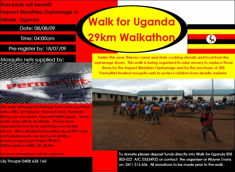
This walk was organised and led by Lily T:
Saturday 8 August – Walk for Uganda – L/E; M(9). Walk from Heritage Park in Forde to Parkway on the corner of the Tuggeranong Parkway and Sulwood Drive in Kambah to raise money for a children's orphanage in Uganda. Around 29km (32km determined after a full recce) and ~150m climb. Maps: Hall and Canberra. Unlimited walkers welcome! Leader: Lily T, but bushwalkers should contact John Evans – jevans@pcug.org.au, (h) 6288 7235. Transport: TBA. Further details at http://jevans.pcug.org.au.
8 of us met at 4am in Forde, plus our wonderful support vehicle driver.
Walk
A perfect morning, though very dark and about -4°C at 4am. After the cars finished circling and all the starters were ready, we set off. The party consisted of Aileen, Andy, Dave, Greg, Lily, Neralie, John and me. Hope we didn't wake too many nearby residents with all our chatter. Young legs quickly took the lead, with Dave and Andy setting a cracking pace. Down the S side of Yerrabi Pond with ducks quacking and swans swan-ing in the dark. It was cold on bare legs and gloveless hands! Down Gundaroo Drive the first mutiny occurred, with half the party on one side of the road and the other half on the other. But we joined again on Gungahlin Drive, the 3km mark slipping past in a mere 34mins. Too cold to stop for our regulation break, nearly running to keep up with the youngies.
Pretty boring down Gungahlin Drive between Palmerston and Mitchell, but the conversations kept things bright. 6km bolted in 1hr 10mins, which made it 5.15am, so I knew breakfast would be early. It was planned for the 9km mark at the Ellenborough St horse paddocks entrance, so a phone call went out to Jeff the support man to put on his chef's hat. We arrived and only had to wait a few minutes before orange juice, bacon and egg rolls and hash browns arrived - just the tucker for active folk, even if it sat a fraction heavily on the tummy. The front seat of the car was popular for some - not for that, but to try to warm up. 20mins for breakfast (see pic 1). Our wonderful organiser and leader, Lily, was interviewed. ![]() Interview with Lily at breakfast (WAV file, 1 min 20secs - turn your speakers on).
Interview with Lily at breakfast (WAV file, 1 min 20secs - turn your speakers on).
It was still a little dark for wandering off-track, so a careful entrance into the North Lyneham Eucalypt Plantation. Time to think of Greg having to go to earn the daily bread, but he had another hour until leaving us. Quickly through this area, passing the 9km + breakfast mark at 2hrs 5mins. Down and across Ginninderra Drive and into the O'Connor Ridge Nature Reserve.
A pleasant stroll through this area. Once again, we called on Jeff to go to the Dryandra St O'Connor pickup point and we said good-bye to Greg as he turned left down the bike path to be picked up, whisked home for a shower and to go to work. The remaining party, now 7, crossed over into the Bruce Ridge Nature Reserve, picked up the ridge-top track and headed SW towards the Belconnen Way crossing. 12km slipped by in 2hrs 30mins walking time. The sun was up by this point and we were grateful for its warmth. Previously, we'd enjoyed it to the NE and the nearly full moon to the SW.
We pressed on through the Black Mountain Nature Reserve, enjoying (?) the panoramic view over Caswell Drive at the end of the Powerline Trail before turning SE down the 1970s concrete path through the bush. 15km happened just after crossing under Caswell Drive into the Aranda Bushland Nature Park and, although we had lost contact with the advance party, we in the rearguard passed it in 3hrs 20mins walking time. It was 7.50am.
We regrouped at the top of the easement through the leasehold Glenloch property down towards the Aranda Snow Gums. Passed a couple of dog walkers and joggers. We stopped briefly at the wonderfully shaped benches and the moment was recorded for posterity (see pic 2).
Through the Snow Gums and across the 2 stiles onto the Belconnen to Civic bike path, we headed SE towards the underpass under William Hovell Drive. Once again, we called on Jeff and the support vehicle to come to pick up Dave for footy and John for family duties. They continued on to the big new Black Mountain car park and the remaining party headed into the Glenloch Cork Oak Plantation. A lovely area, appreciated by those new and those revisiting alike. Not quite sure of the response when we reached the S end and had to do an about turn, as the Canberra International Arboretum and Gardens is closed as a construction site on all days but Sunday. BTW, did you catch Ros R on ABC Stateline last night? She is the project director for the arboretum and has been very helpful on this and other occasions. However, we needed to respect the fact that we could not traverse the area today.
Back N and then E along the bike path, we walked through the 18km mark in 4hrs 18mins at 8.47am. With 1km left to our planned lunch stop at Acacia Inlet at 11.45am, we were obviously way ahead of schedule. Andy had kept us moving quickly. So more phone calls, to delay lunch till Scrivener Dam. A bit boring for walking as we skirted Glenloch Interchange to the E and S on the bike paths, but the conversation was still flowing and bright (Alice - your prayers were answered!). The toilets at Acacia Inlet were appreciated by some and I phoned my son in San Diego on his birthday.
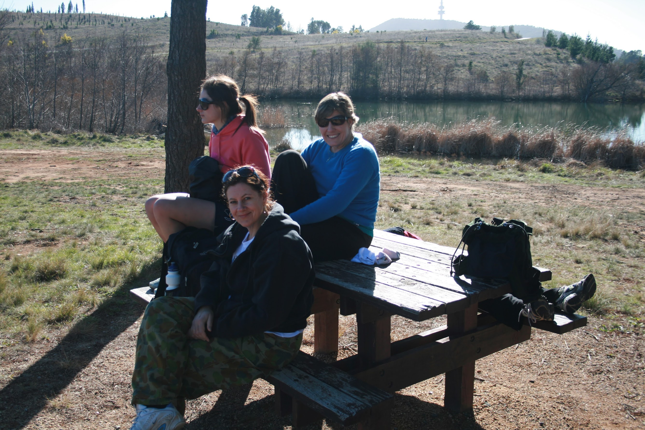
We should have done the Yarramundi Reach loop, but didn't. We put in a call to our senior minister who kindly agreed to meet us for lunch. But progress remained rapid. We passed through 21km in 5hrs walking time. Add the 20mins for breakfast and it was 9.30am. We'd agreed on 10am to meet the others, so when we arrived at the picnic area opposite the National Zoo and Aquarium at 9.33am we called a halt. Nice to sit the the sun for 20mins (see pic 3). Our resident physiotherapist, Aileen, was interviewed. ![]() Interview with Aileen near Scrivener Dam (WAV file, 1 minute - turn your speakers on). Tranquil views along Lake Burley Griffin (see pic 4).
Interview with Aileen near Scrivener Dam (WAV file, 1 minute - turn your speakers on). Tranquil views along Lake Burley Griffin (see pic 4).
Over Scrivener Dam and to the car park on the SE side, our wonderful Jeff arrived with a huge platter of meat and salad rolls (thank you Jeff and Subway) and other goodies. Our senior minister (who was up till 3am, maybe praying for us) arrived and so did Ante. Time to joke around, eat lunch (or breakfast, if that was what it was for you) and wait for others to join us. Initially only coming for lunch, Ps John decided to walk on with us. 50mins for lunch.
Stan and Isobel, and Steven, joined us to walk on. Jeff and Ante drove off. Our next leg took us along the bike path beside the Molonglo River, then up the public horse trail easement beside the Yarralumla Woolshed and around the riding school to the Yarralumla horse paddocks. 24km came and went in 5hr 45mins walking time. That's not bad - an average of 4.2km/hr. A few tens of metres took us to Cotter Road, where Aileen had to leave us to coach her son's hockey team.
Very pleasantly warm as we walked the bike path up the W side of Curtin, past yet another stand of Cork Oaks. The day remained picture perfect with blue sky all around. Here and elsewhere, lovely views to the Tidbinbilla and Brindabella Ranges to the W and SW. We veered SW to the Illoura horse paddocks, then out to the elbow of the Heysen/Devonport Sts intersection.
Across into the Oakey Hill Nature Reserve and we were beginning to smell completion. A 4pm finish seemed most unlikely and various alternative arrangements were made. Amid continuing fun chats (with a touch of blistering toes for some) we walked through 27km on the E side of Oakey Hill at 12 noon.
Pressing S, we passed under Hindmarsh Drive, where Steven left us. Andy, Ps John, Lily, Neralie, Stan and Isobel and this good story teller remained. A little of Waldock St, under the Tuggeranong Parkway, through 30km, a pause for a party member to catch some rays, then the final jaunt with the Parkway building in sight. Most took the back entrance to the church; only Isobel and I took the elegant front drive approach. In by 1.05pm.
Nice to sit in the foyer, ring our trusty Jeff and Ante for transport, remove shoes and stretch. Ps John provided us with words of inspiration. ![]() Interview with Pastor John at the finish (WAV file, 1 minute - turn your speakers on) Only someone who has devoted his life to the Lord can be this crazy, so no one can take offence!
Interview with Pastor John at the finish (WAV file, 1 minute - turn your speakers on) Only someone who has devoted his life to the Lord can be this crazy, so no one can take offence!
Well done to those who did the entire walk - Lily T, Andy P, Neralie L and John E. And also well done to Dave B (who also won his AFL match), Greg K (who also earned his daily bread), John C (who also met his family responsibilities), Aileen C (who left to coach her son's hockey team), Stan and Isobel L and Steven (all joining us at Scrivener Dam) who joined us for various parts of the walk and fitted in various other work, sporting and family commitments on the day. Oh, I nearly forgot, that crazy guy, our senior minister, Pastor John M, joined us for the last third of the walk. And the comings and goings, great tucker and other transport needs would not have happened except for Jeff B and Ante P.
Distance: 31.7km Climb: 200m. Time: 4.05am - 1.05pm (9hrs), with 1.5hrs of stops. That's an average of 4.2km/hr.
Grading: L/E; M(9)
KMZ file for Google Earth/Maps: Walk for Uganda
Thank you for those who so generously sponsored the walkers. By faith, 300 mosquito nets - one for each bed in the orphanage - and additional items (to replace those stolen earlier in the year) were purchased. There remains a shortfall of funds; please donate if you haven't already.
Further Information
Lily was part of the Parkway team who went to Uganda in October 2008. She wants to do more and says in the Facebook event Walk for Uganda:
This is a ministry dear to my heart. I visited the orphanage in October 2008. Beds were unprotected from mosquitoes. There was only two nets on two beds. The nets had holes and many children had been suffering from malaria. Recently thieves came and stole food supplies and cooking utensils from the orphanage and food is in short supply.
I plan to walk 29km from Forde to Parkway in Kambah in the ACT, in Canberra the capital of Australia on Saturday, 8 August 2009. I will set out in the early morning, to arrive by nightfall. I have never walked so far, the most I've walked is 20kms, so please if anyone can help me train, then let me know.
I am also seeking volunteers to help me out with water, walking, food along the way and also getting the word out there for sponsors.
I hope to do this in one day, weather, time, and fitness permitting, so I'm asking for your prayers for this event also.
So many Ugandans walk 20kms plus just to buy food and provisions, so why can't we get off our butts and do the same for them on one weekend? Get involved, contact me to sponsor this event and donate some money NOW, as I won't be collecting after the event.
I'll trot along on the walk so if you have ever got anything from this blog, please consider contacting me to sponsor me. If you've ever walked with me on Tuesdays, I'll contact you to twist your arm to sponsor me. And why not join us - a warm up (well, in distance) for the annual CBC Worn Boot Bash on 19 Sep 09.
THIS INFORMATION IS FINAL - Last updated 27 July
Proposed Route - see UBD Directory in Yellow Pages, maps 29, 39, 48, 58, 67 and 77. The Canberra Cycling and Walking Map is also helpful.
- START - Heritage Park, Francis Forde Boulevard, Forde (UBD in the Yellow Pages Map 29 M2). Be there ready to walk by 4am
Walk down Francis Forde Boulevard to the T-intersection with Horse Park Drive. (VERY CAREFULLY) cross Horse Park Drive and turn left onto the bike path for around 150m. Veer right and follow the bike path/walking track along the south side of Yerrabi Pond and through to the Gungahlin Town Park/Yerrabi Pond District Park. (VERY CAREFULLY) cross Mirrabei Drive and follow the concrete path along the north side of Gundaroo Drive. (VERY CAREFULLY) cross Nari St. Continue along the concrete path to the underpass under Gundaroo Drive near the intersection with Gungahlin Drive. Use it to go under Gundaroo Drive. (CAREFULLY) cross Gungahlin Drive at the traffic lights to the Palmerston corner of the intersection and turn left onto the bike path along Gungahlin Drive. Follow the bike path, (CAREFULLY) crossing Kosciuszko Avenue at the traffic lights - 5am, 3km - and, further along, (CAREFULLY) cross Kosciuszko Avenue at the traffic lights again. Continue to follow the bike path across the back of the houses of Palmerston and beside the Gungaderra Grasslands Nature Reserve to opposite Sandford St Mitchell - 6am, 6km.
- EXTRACT POINT A - Sandford St Mitchell, around 100m east of the Sandford St/Gungahlin Drive T-intersection, at the entrances to Gungahlin Cemetery and Norwood Park Crematorium (YBD in the Yellow Pages Map 39 J7)
- (CAREFULLY) cross Gungahlin Drive at the traffic lights to the south corner of the T-intersection. Follow the bike path along the side of the Crace Grasslands Nature Reserve, sweeping around the Gungahlin Drive/Barton Highway interchange, to the underpass under the Barton Highway. Use it to go under the Barton Highway. Veer right to the north side of Ellenborough St. (VERY CAREFULLY) cross Ellenborough St to the south side and pick up the bike path going west. Follow it around 200m to the fence line leading to the northern end of the Lyneham Ridge Eucalypt Plantation - 7am, 9km, 30min breakfast, 7.30am.
- EXTRACT POINT B - Entrance to Kaleen Horse Paddock from Ellenborough St (UBD in the Yellow Pages Map 39 D12)
- Veer left up the fence line and cross the fence at the handy horizontal metal piping. Follow management trails south through the Lyneham Ridge Eucalypt Plantation, keeping within earshot of the GDE. (Here, up in the trees, could be the opportunity for a wee break.) At the dam, veer right-ish and follow the management trail to the corner of the plantation above the Ginninderra Drive/GDE interchange. Squeeze through the triangular posts especially there for walkers. (CAREFULLY) cross Ginninderra Drive at the traffic lights. Either hop the fence into the Bruce/O'Connor Ridge Nature Reserve and walk across the grassland corner to the walking track around 100m on, or go south on the right side of the fence between it and below the GDE for around 100m to the walkers entrance point and nearby sign post.
- Follow trails and management tracks south through the O'Connor Ridge Nature Reserve, keeping within ear-shot of the GDE. At the south-western edge of the O'Connor Ridge Nature Reserve, walk through the rocks beside the gate, across the bisecting bike path and into the Bruce Ridge Nature Reserve. Take the management track veering left which parallels the bike path for 300m. At the next track junction we are within sight of the Dryandra St car park.
- EXTRACT POINT C - Car park opposite 160 Dryandra St O'Connor (UBD in the Yellow Pages Map 48 Q7)
- Turn right and follow management trails - 8.30am, 12km - across the back of the caravan park and continue along this straight stretch all the way to Belconnen Way. (Alternatively, just before the 132kV power line crosses the track, strike right up through the bush to pick up the ridge line management trail, past one reservoir in the middle of the Nature Reserve and onto the second. From the south corner of the second reservoir, follow a bike track down to the edge of Belconnen Way.) (VERY CAREFULLY) cross Belconnen Way, slanting to the right.
- EXTRACT POINT D - car park off Belconnen Way going west, about 400m before the Belconnen Way/GDE intersection (UBD in the Yellow Pages Map 48 J9)
- From the car park, cross the stile and go right along the Pipeline Trail. Turn right into Orchid Trail and follow it along under the powerlines to the point overlooking the GDE. Turn south and east along a short footpad to pick up the concrete walking track to the intersection with a management track which goes down to the underpass under Caswell Drive. Use it to go under Caswell Drive. Go right for a few tens of metres, then turn left on a management trail which heads SW - 9.30am, 15km - to reach the boundary of the Nature Reserve - there are at least two signs announcing private property over the fence. Continue until reaching the easement provided by the lessee of Glenloch which goes left down to magnificent specimen eucalypts, signage and some rustic benches. Follow the footpad marked with an occasional pole out into the open paddocks and to the Aranda Snow Gums. Head for and cross two styles giving access to the bike path. Turn left and go down to the underpass under William Hovell Drive. Use it to go under William Hovell Drive, then left through the gate into the Cork Oak Plantation. Walk south along the trail through the plantation to the far end. Turn around and come back, appreciating the uniqueness of the area. Retrace the way under William Hovell Drive and right onto the bike path - 10.30am, 18km.
- Continue east along the bike path, crossing under Old Caswell Drive and Caswell Drive. Swing south, following bike path directions to Woden. Cross under the various Parkway roads at Glenloch Interchange three times. (CAREFULLY) cross Lady Denman Drive at the traffic lights. Follow the bike path to the toilets south-west of Acacia Inlet - 10.45am, 19km. 30m further on is a picnic area for 1hr lunch, 11.45am.
- EXTRACT POINT E - Acacia Inlet Road (open Sat, Sun, PH) off Lady Denman Drive, about 100m west of the bike path crossing traffic lights (UBD in the Yellow Pages Map 58 F4)
- Follow the bike path across Yarramundi Peninsula - at Barrenjoey Drive there is an optional extra loop of 1.6km down to the edge of Lake Burley Griffin, with nice views across to Government House at Yarralumla - then through the additional cork oak area - 12.30pm, 21km - and down to Scrivener Dam. Cross the dam wall on the north-east (lake) side, then through the underpass to Scrivener Dam car park.
- EXTRACT POINT F - Scrivener Dam car park (UBD in the Yellow Pages Map 58 A11)
- Follow the bike path, veering to the right and across the bridge over Yarralumla Creek. Where a horse trail comes up from the Mologlo River ford, turn left into the horse trail easement and follow it. It becomes a "Public Bridle Path" which runs across the back of the riding school to the Yarralumla Horse Paddocks - 1.30pm, 24km. Walk out the public road to the Cotter Road.
- EXTRACT POINT G - Cotter Road turn into Greenleigh Central Canberra Motel, swimming pool and Riding School (UBD in the Yellow Pages 67 Q2)
- (VERY CAREFULLY) cross the Cotter Road and go directly through a posted walk-through in the fence line. Join the concrete strip bike path which curves up the hill behind the backs of houses in Curtin. Opposite the well-kept concrete block house with a flat roof, veer right up past the south end of the oak plantation to the fence line. At the easement with the sign 'Cyclists Beware Horses' turn right and follow the easement down, through the Illoura Horse Paddocks holding yard, to the car park. Turn left along the access road and follow it (or left along the easement to the Pound then right through the gates and paddock) to the elbowed corner of Heysen St and Devonport St in Lyons.
-
EXTRACT POINT H - Elbow at Heysen St/Devonport St Lyons (UBD in the Yellow Pages Map 67 Q9)
-
From the gate into the Illoura Horse Paddocks, (VERY CAREFULLY) cross Heysen St to the electricity substation and walk uphill for 30m to the horse step-through. Follow the service track along the west boundary fence of the substation, then along the east flank of Oakey Hill - 2.30pm, 27km, 15mins arvo tea, 2.45pm - with the backs of the houses in Lyons on your left. Near the south-east flank of Oakey Hill, continue to follow the service track as it veers right, then down to Hindmarsh Drive. Use the underpass under Hindmarsh Drive. Continue up the concrete bike path, then veer right onto the dirt service track, then cut the corner along the dirt footpad. Gain the elbow in Waldock St Chifley.
- EXTRACT POINT I - Elbow in Waldock St Chifley (UBD in the Yellow Pages Map 77 Q3)
- (VERY CAREFULLY) walk the black-top for a couple of hundred metres, then right via the bike path and underpass under the Tuggeranong Parkway. Follow the bike path as it turns left along the west side of the Tuggeranong Parkway and the east side of the back of houses in Fisher - 3.30pm, 30km. Watch for bicycles. Follow the bike path to the corner of the Tuggeranong Parkway and Sulwood St. Turn right and enter the grounds of Parkway - 4.00pm, 32km.
- FINISH - Parkway, cnr Tuggeranong Parkway and Sulwood Drive, Kambah (UBD in the Yellow Pages Map 77 J11)
If you have the Google Earth application loaded, click here to see the proposed route.
Or view map segments showing the proposed route (note that these are prior to the building of the GDE). Click on the album thumbnail below, click on the map segment thumbnail (one picture for each 3km of the proposed route), then use the magnifying glass icon to zoom in for a better view:
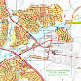 |
| 2009 08 08 Walk for Uganda proposed route |
Timing
With a 12hr day planned, the pace should average 3km/hr, + 30min breakfast + 1hr lunch + 15min arvo tea = 12hrs, 4am - 4pm. Each 'hour' of walking includes a 5 minute break.
Civil twilight (that's 'just see' in ideal conditions): 0626 - 1753
Extract/Entry/Support Points
If you only want to walk part of the route, or find yourself wearying and want to be extracted, you should have a mobile phone with you and a non-walking friend available to come and drop you off/pick you up at one of the designated points below. These are safe areas (other areas such as major roads are not necessarily safe for vehicle or walker). The Walk for Uganda has a support vehicle, but the focus of this resource is on the group as a whole. If you want to join/leave/are forced to leave, you need to have your own plan in place. In addition, timing points are a little rubbery. Have the organiser's (published prior to the walk) or my (published prior to the walk) mobile phone number and ring to find out where we are.
START - Heritage Park, Francis Forde, Boulevard Forde (UBD in the Yellow Pages Map 29 M2)
EXTRACT POINT A - Sandford St Mitchell, around 100m east of the Sandford St/Gungahlin Drive T-intersection, at the entrances to Gungahlin Cemetery and Norwood Park Crematorium (YBD in the Yellow Pages Map 39 J7)
EXTRACT POINT B - Entrance to Kaleen Horse Paddock from Ellenborough St (UBD in the Yellow Pages Map 39 D12)
EXTRACT POINT C - Car park opposite 160 Dryandra St O'Connor (UBD in the Yellow Pages Map 48 Q7)
EXTRACT POINT D - car park off Belconnen Way going west, about 400m before the Belconnen Way/GDE intersection (UBD in the Yellow Pages Map 48 J9)
EXTRACT POINT E - Acacia Inlet Road (open Sat, Sun, PH) off Lady Denman Drive, about 100m west of the bike path crossing traffic lights (UBD in the Yellow Pages Map 58 F4)
EXTRACT POINT F - Scrivener Dam car park (UBD in the Yellow Pages Map 58 A11)
EXTRACT POINT G - Cotter Road turn into Greenleigh Central Canberra Motel, swimming pool and Riding School (UBD in the Yellow Pages 67 Q2)
EXTRACT POINT H - Elbow at Heysen St/Devonport St Lyons (UBD in the Yellow Pages Map 67 Q9)
EXTRACT POINT I - Elbow in Waldock St Chifley (UBD in the Yellow Pages Map 77 Q3)
FINISH - Parkway cnr Tuggeranong Parkway/Drakeford Drive and Sulwood St Kambah (UBD in the Yellow Pages Map 77 J11
What to Wear/Bring
- Footwear - an urban walk on bike paths and benched walking tracks. Your choice for personal comfort, maybe sneakers unless you need boots for ankle support. Two pairs of socks. Our feet will get a little sore from the hard, flat surfaces. Bandaids for blisters!
- Clothing - layers. It will be cold at 4am and towards the end of the day; hot and sweaty walking. Rain jacket if likely to be wet - this walk happens rain, hail or shine.
- Food and water - best to be self-sufficient as it's hard to time resupply. Plenty of energy food for snacks and lunch. At least two litres of water. A light breakfast and lunch may be available.
- Gizmos - mobile phone, camera, torch/head torch for the first couple of hours.
Toilets
There is only one toilet on the route, at Acacia Inlet at lunchtime, after about 19km. I will carry a small poo-tube, available to deposit paper and other non-biodegradable items in.
Recces
We recce-d all the proposed route:
- On Monday 15 June - Heysen St/Devonport St Lyons to Parkway
- On Saturday 20 June - Gungahlin; Lyneham Ridge Eucalypt Plantation; N Black Mountain
- On Sunday 21 June - Belconnen Way to Zoo
- On Saturday 27 June - O'Connor Ridge and Bruce Ridge Nature Reserves - Ginninderra Drive to Belconnen Drive; Molonglo River - near Zoo to Cotter Road
- On Tuesday 30 June - Cotter Rd to Lyons
- On Monday 6 July - around the International Arboretum (permission not available to walk through the construction zone, except on Sundays)
- Lily would like to recce the lot - we need a third person to assist us. Did a bit with her kids on Saturday 4 July
- On Sunday 28 June we had a ramble to Gibraltar Peak and on Sunday 12 July we'll do a Parkway Ramble to Square Rock - to get in a bit of training
- On Saturday 25 July we'll have a Parkway Ramble from the Mt Clear car park in the southern ACT. Around 11km and 200m climb, we'll visit Potters Chimney, take the Long Flat Fire Trail to Sam Abouds Dunny, down the creek to Chalkers Chimney, NW cross country to the Naas Valley Fire Trail, visit John Brayshaws two hut sites and back to the cars via the Mt Clear site.
Click on a thumbnail below to see the full sized picture